











هذا التقرير متاح أيضًا بـ العربية
The Ali al-Taher hills may appear on the Lebanese map as a limited area near Nabatieh in the country’s south, but in battlefield calculations they have become a knot where surveillance, firepower and politics converge.
This high ground, located north of the Litani River between Kfartebnit and Nabatieh al-Fawqa, overlooks the city of Nabatieh and its approaches, and geographically links Beaufort Castle with the Litani axes and the Iqlim al-Tuffah region.
That is why the hills have recently become a major test for the Israeli occupation, which is trying to expand its zone of control deeper into Lebanon; for Hezbollah, which sees them as a defensive line for Nabatieh and the south; and for the Lebanese state, which finds itself facing questions of sovereignty, the army’s role and the implementation of UN Security Council Resolution 1701.
A geographic knot above Nabatieh
Located the Ali al-Taher hills or heights are in the Nabatieh district north of the Litani River, between Kfartebnit and Nabatieh al-Fawqa, with a direct line of sight over Nabatieh and its eastern and northern extensions.
The hills rise about 600 meters above sea level, while some nearby points reach roughly 655 meters, giving them a broad ability to overlook Nabatieh and its surroundings.
Ali al-Taher lies at the center of a sensitive geographic circle. To the south and southeast stretch Kfartebnit and the axes of Arnoun, Zifta and al-Maabar, which serve as approach routes toward the hills.
In the same direction lies Beaufort Castle, a height overlooking the Litani’s course, and advancing from it creates additional pressure toward Kfartebnit and the slopes of Ali al-Taher.
To the west and northwest, the hills overlook the city of Nabatieh, its entrances and roads, while Nabatieh al-Fawqa sits on the slopes closest to the site.
To the north, Kfarreman falls within the circle of villages affected by any shelling or military movement around the hills, especially as strikes have extended to the nearby al-Dabsha neighborhood. To the east and northeast, the woodlands and slopes connect to Iqlim al-Tuffah and the Rihan heights.
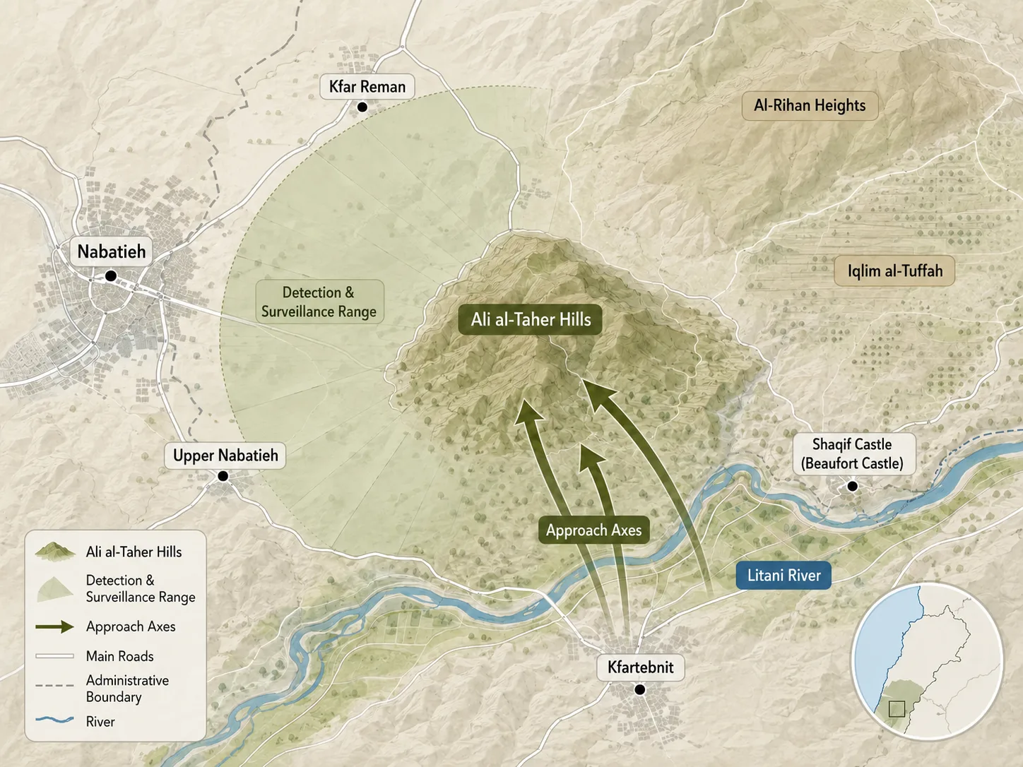
With this geography, Ali al-Taher becomes a linking point between Nabatieh, the Litani, Beaufort Castle and Iqlim al-Tuffah, and its value shifts from a mere local elevation to a site for surveillance and fire control over wide axes in southern Lebanon.
The hills’ military value begins with their relationship to Nabatieh. Retired Brig. Gen. Hassan Jouni says the hill overlooks the city and allows monitoring of most of its entrances, exits and neighborhoods, meaning that control of this height grants direct influence over the Nabatieh area and the road network connected to it.
The hills’ relationship to the Litani River further heightens the site’s sensitivity. Ali al-Taher lies north of the river, and any Israeli movement in this area is read in Lebanon as a deeper incursion into a zone that is supposed to be governed by Resolution 1701, the international framework for halting the fighting in the south and for the deployment of the Lebanese army and the United Nations Interim Force in Lebanon, or UNIFIL.
That is why the hill becomes a matter of sovereignty and ceasefire, because the occupation’s continued presence in this geography means entrenching a fait accompli on Lebanese land.
What does the occupation want from the hills?
Since the first half of June 2026, occupation forces have been trying to turn the Ali al-Taher hills from a height overlooking Nabatieh into part of an advanced military control zone inside southern Lebanon.
Reading what has happened on the ground requires distinguishing among three different levels: incursion into the hills’ surroundings, deployment or a ring of fire around them, and full control of the summit itself.
Israeli newspapers sometimes use the name “Ali al-Taher” to refer to the sector surrounding the hill, while Lebanese sources confine the discussion to the summit and the immediate heights.
Yedioth Ahronoth said occupation forces remained in the Ali al-Taher sector within what “Tel Aviv” calls the “security” zone, reaching depths of up to 10 kilometers inside Lebanon at some points.
Official Israeli statements reveal the battle’s objective more clearly. In a document issued by the General Staff on July 2, 2026, the occupation army said its forces continue to deploy in what it calls the “security area” to prevent infiltration operations and anti-tank fire, and that they had taken control of the Beaufort and Ali al-Taher heights and the positions between them, which it considers strategic Hezbollah infrastructure.
The occupation army’s chief of staff, Eyal Zamir, also said on June 21 that Ali al-Taher and Beaufort represent one of Northern Command’s current “centers of gravity,” describing the area as an “underground fortress” built by Hezbollah over two decades.
The main Israeli claims revolve around the existence of a vast underground complex in Ali al-Taher. The Times of Israel described the site as a command center for Hezbollah’s Badr Unit.
For its part, The Jerusalem Post spoke of sub-complexes and an underground command structure, while some of these accounts relied on the Israeli research center Alma , which has a security and intelligence background.
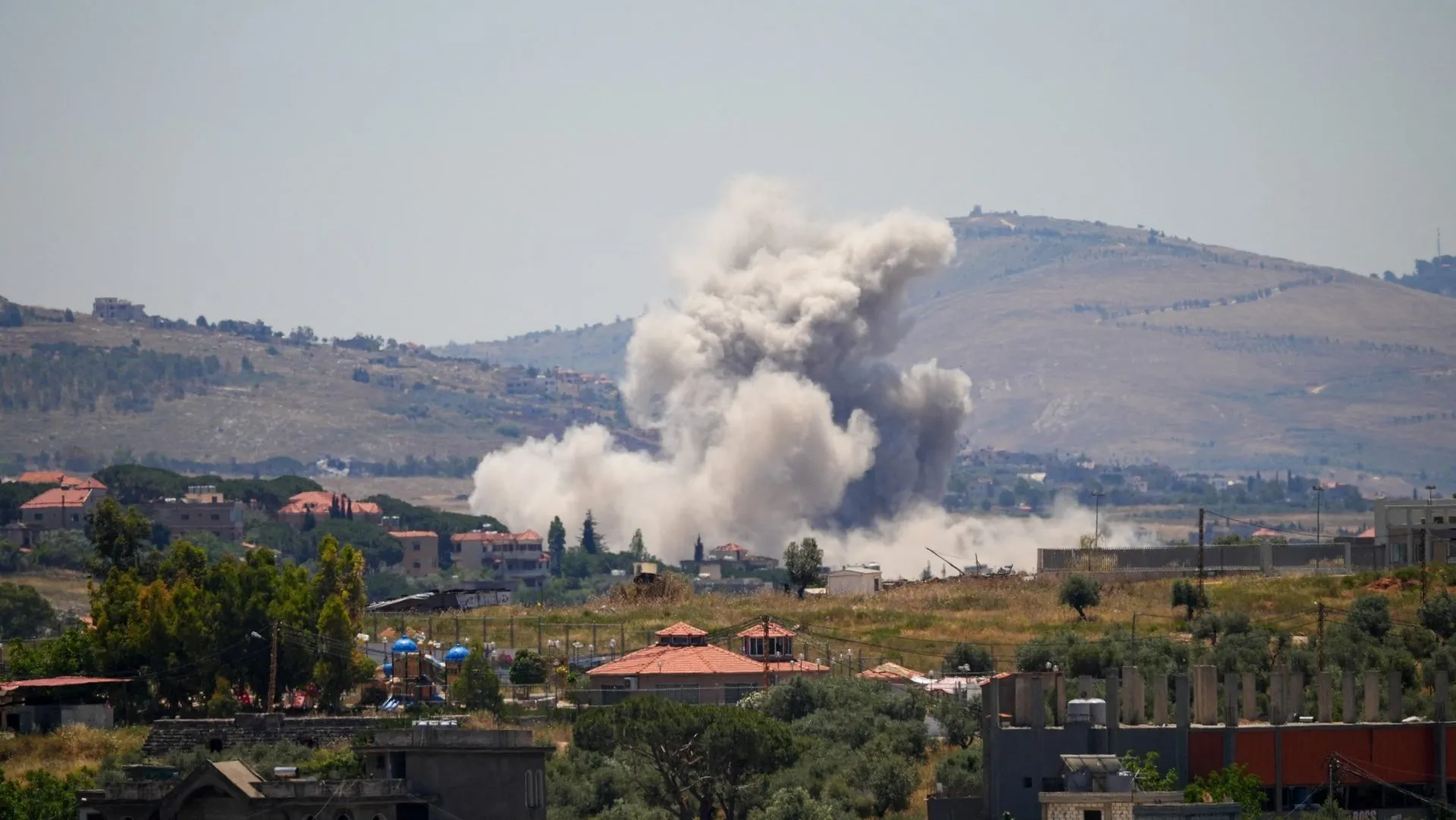
Whatever the description of the facilities, the battle over the hills has gone beyond airstrikes to direct ground clashes. On June 19, Reuters said the fiercest fighting was concentrated in the Ali al-Taher area north of the Litani, where occupation forces sought to push in.
The following day, The Times of Israel reported that an Israeli soldier was killed and 13 others wounded during operations inside the area, while The Jerusalem Post had reported days earlier that two soldiers were wounded during what it called “military activity” in the area. These incidents confirm that the occupation carried out a direct ground incursion in the vicinity of Ali al-Taher.
Ella Waweya, the Arabic-language spokesperson for the occupation army, claimed on June 26 that the area was under full control, while sources in Hezbollah denied this and said the Israeli incursion had been in its surroundings.
Al Jazeera quoted a Lebanese military source as saying the Lebanese army had not detected any Israeli advance to the summit, while Alhurra quoted a Lebanese military source as saying the occupation was encircling the hill’s surroundings and imposing fire control over the sector without reaching the summit.
The occupation’s objective does not stop at battlefield control. Ali al-Taher has also become a bargaining chip within the idea of “experimental zones ” floated during ceasefire contacts.
Al Jazeera reported that “Israel” proposed bringing the Lebanese army into Ali al-Taher as a pilot model before signing the framework agreement, but the Lebanese side rejected this because the hill is not originally occupied territory.
Sources also said that “Israel” raised the issue of the hill again during the Washington talks as one of the experimental zones, while Lebanon insisted that any withdrawal or new arrangements must begin with the areas actually under occupation.
Ali al-Taher thus shifts from a military height to a political card that helps determine the shape of the Israeli presence, the limits of the Lebanese army’s deployment and the mechanism of any future withdrawal from southern Lebanon.
A test for Hezbollah and the Lebanese state
For Lebanon, Ali al-Taher represents a key defensive line for Nabatieh and the south because of its location linking the city to the eastern heights and the Beaufort-Litani axis. Hezbollah is holding on to the area because losing it would give the occupation an advantage in surveillance, fire management and the threat to supply lines and troop movement.
The hills’ importance to Hezbollah accumulates on more than one level. Militarily, the area provides visual and fire coverage and links the Nabatieh sector with Iqlim al-Tuffah. In the Israeli narrative, the occupation claims the area contains command-and-control infrastructure tied to the party’s Badr Unit.
Historically and symbolically, the site was one of the most prominent Israeli fortifications during the occupation period until 2000. The presence of the shrine of Ali al-Taher, a local religious landmark within the heights, also gives the place a symbolic dimension beyond its military value, because it ties the hills to the memory of place around Nabatieh. That is why any battle over the hills is read among Hezbollah’s base as a confrontation over the memory of occupation and liberation.
Any sustained Israeli entrenchment in Ali al-Taher would partially expose the Nabatieh sector, complicate movement between Kfartebnit, Nabatieh al-Fawqa and Kfarreman, and give the occupation a field card through which it can present an incursion north of the Litani as something feasible.
It would also open the door to expanding the concept of the “security zone” deeper into Lebanon, putting pressure on Hezbollah over the issue of weapons and withdrawal, and placing part of its vital environment under the occupation’s eye and fire, or under the threat of both.
By contrast, the occupation’s failure to entrench its control and its settling instead for a ring of fire and repeated shelling gives Hezbollah political and symbolic space to present the hills as evidence of the limits of Israeli power.
But this scenario does not ease the burden on the surrounding villages, because the continuation of the encirclement and shelling means civilians, roads, woodlands and residential areas remain under the pressure of strikes, raids and displacement.
Ali al-Taher places the Lebanese army in an extremely sensitive position. It says it is coordinating with UNIFIL on a mechanism to monitor the ceasefire in order to strengthen stability south of the Litani, but it faces a complex field reality extending to Nabatieh and the hills north of the river.
Under the “experimental zones” proposal, the army is meant to take over land from which the occupation withdraws, while effectively being tasked with dealing with Hezbollah’s infrastructure and weapons without sliding into internal confrontation.
Ali al-Taher thus becomes a test of the Lebanese state’s ability to hold sensitive ground amid maps imposed by the occupation on the battlefield and then reintroduced politically at the negotiating table. From the perspective of the ceasefire and Resolution 1701, the hills expose the gap between international texts and the realities the occupation creates on the ground.
UNIFIL stresses that any Israeli presence inside Lebanon constitutes a violation of Resolution 1701, and that long-term stability requires a full withdrawal and the effective deployment of the Lebanese army in its area of operations.
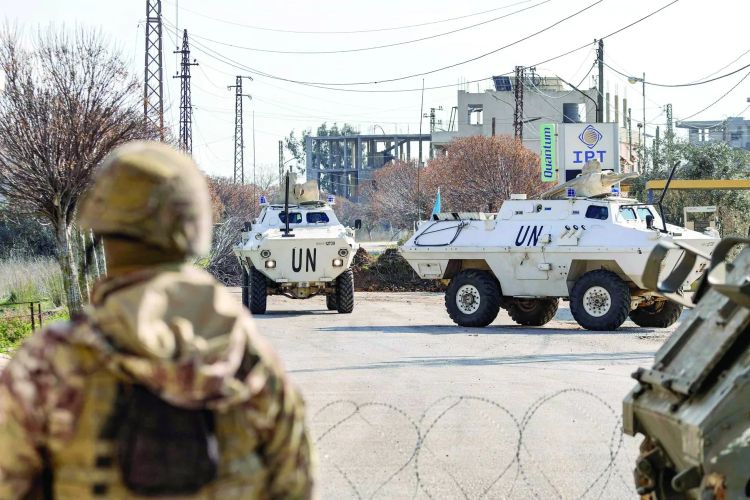
If Ali al-Taher remains within an area encircled or retained by the occupation, ceasefire understandings become cover for a fait accompli that goes beyond the UN resolution. If it withdraws under a clear mechanism, the hill becomes a test of the Lebanese army’s and the state’s ability to hold an extremely sensitive site and prevent the return of fighting around it.
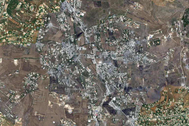
As for civilians in Nabatieh al-Fawqa, Kfartebnit and Kfarreman, they have paid the price for Ali al-Taher’s transformation into a flashpoint. L’Orient Today reported continued targeting and raids near Kfarreman and Nabatieh al-Fawqa, while satellite images were published showing destruction, fires and major changes to the land and roads.
Israeli aggression around Nabatieh and Ali al-Taher also forced residents to flee, after which some returned cautiously while others remained away from their villages. Any new Israeli attempt to seize the hill, or any confrontation to prevent that, will therefore directly affect return, roads, woodlands, housing and humanitarian access.
Inside Lebanon, Ali al-Taher encapsulates a dispute broader than its geographic limits. It confronts the state with the question of whether to negotiate from a position of recovering land or of receiving terms, and it places the army before the test of deploying in an extremely sensitive area.
It also gives Hezbollah material to argue that its weapons remain a defensive necessity in the face of Israeli incursions. By contrast, its opponents use such sites to argue that military infrastructure outside the state gives the occupation an additional pretext to advance and impose facts on the ground.
And Reuters described , along with the British Financial Times, the framework agreement between Beirut and “Tel Aviv” as liable to inflame Lebanese divisions because it links Israeli withdrawal to Hezbollah’s disarmament, while Lebanese President Joseph Aoun defended negotiations as a path to securing withdrawal without giving up “a single inch.”
In this sense, Ali al-Taher has shifted from a local height near Nabatieh into a test of sovereignty, the army, Hezbollah’s role and the limits of a possible settlement in southern Lebanon.
