






هذا التقرير متاح أيضًا بـ العربية
The phrase “south of the Litani” in the arrangements of Resolution 1701 defines a security zone between the course of the Litani River and the Blue Line, and the United Nations uses the area of operations of its Interim Force in Lebanon about 1,060 square kilometers as the closest practical reference for it.
This zone stretches across parts of the districts of Tyre, Bint Jbeil, Marjayoun, and Hasbaya, from the coast between Tyre and Naqoura to the eastern sector at Khiam and the villages adjacent to Ghajar and Kfar Shouba.
And Resolution the United Nations Security Council, on Aug. 11, 2006, stipulated that the area be free of any armed personnel, assets, and weapons, except those belonging to the Lebanese government and the United Nations Interim Force in Lebanon, “UNIFIL,” and tied that to the deployment of the Lebanese Army and the withdrawal of the Israeli occupation.
During the 2026 war, occupation forces expanded the scope of their control inside southern Lebanon, then the US-Lebanese-Israeli arrangements linked withdrawal to the deployment of the Lebanese Army, the collection of weapons, and the dismantling of Hezbollah’s armed positions.
Implementation of these arrangements began in July within “pilot zones” that included towns south of the Litani and others north of the river, making the 2026 plan geographically broader than the scope defined in Resolution 1701, as it included arrangements inside the UNIFIL area of operations and extended to other areas that had come under Israeli occupation control during the war.
South of the Litani on the map
The United Nations uses the UNIFIL area of operations as the closest practical reference for south of the Litani. This area covers about 1,060 square kilometers, and the international force is deployed within it at about 50 positions, nearly half of them on or near the Blue Line.
The Litani River marks its northern boundary along its winding course toward Qasmiyeh and the coast, while the Blue Line extends along its southern edge for about 120 kilometers from Naqoura in the west to the eastern sector.
The UNIFIL operations map dated May 2026 shows the general shape of the area, while a map issued by the United Nations in June 2022 provides the names of towns, roads, and broader geographic details.
The coastal sector extends from Tyre to Naqoura, the central part of the area is anchored by the Tebnine-Bint Jbeil axis and the surrounding border villages, while the eastern sector includes Marjayoun, Khiam, and the towns adjacent to the Blue Line up to the vicinity of Ghajar and Kfar Shouba. Across these sectors are distributed army and UNIFIL positions, linked by local roads connecting them to the main centers north of the Litani.
The area is connected by three main axes: the coastal road between Tyre and Naqoura, the Tyre-Tebnine-Bint Jbeil axis, and the road extending from Nabatieh through Khardali to Marjayoun and Khiam. The Qasmiyeh Bridge and the Khardali axis form two main crossing nodes for the movement of the army, UNIFIL, supplies, and the return of residents.
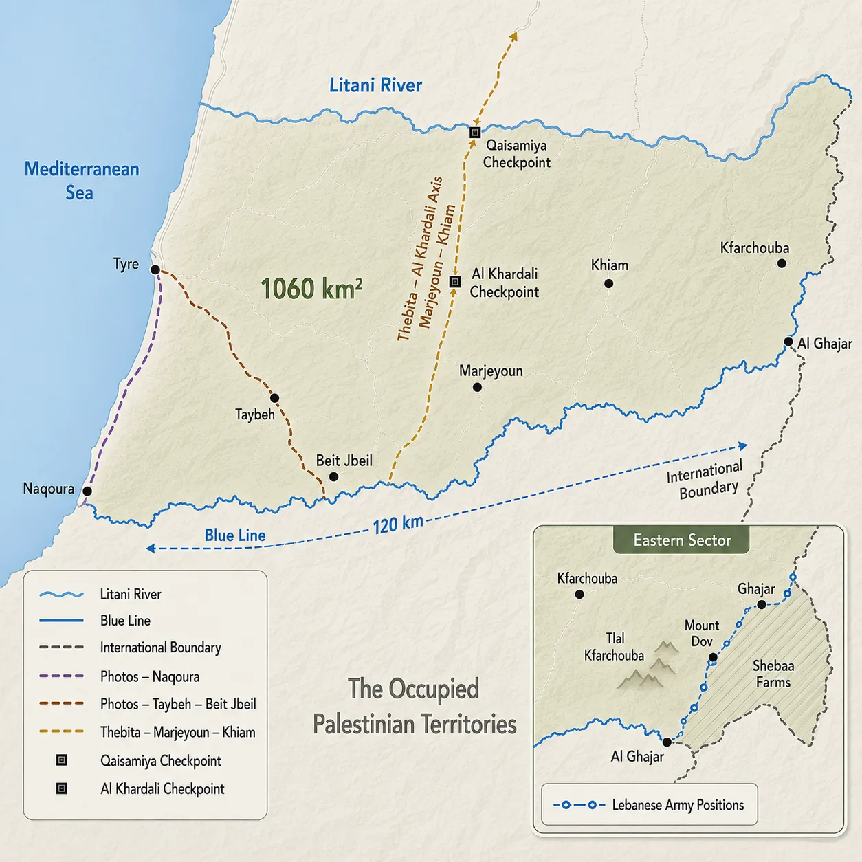
The condition of these bridges and roads determines the ability of the army and UNIFIL patrols to move, the delivery of supplies, and the return of residents to damaged villages, after a number of them were bombed or cut off during the war.
The geographic and legal status of the Litani River, the Blue Line, and the international border differs. The Litani is an internal Lebanese river about 170 kilometers long, and the arrangements of Resolution 1701 adopt it as the natural northern boundary of the security zone.
The United Nations drew the Blue Line in 2000 to verify the withdrawal of occupation forces from Lebanon, and since then it has been used as a field reference for monitoring movements and violations.
As for the historical border reference, it goes back to the 1923 line between the French and British mandates and the 1949 Armistice Line, while the United Nations describes the Blue Line as a tool for verifying withdrawal without representing a final demarcation of the international border.
The northern part of the town of Ghajar and the adjacent area lie north of the Blue Line that is, on its Lebanese side and within the geographic space south of the Litani and this part remains under occupation control outside the authority of the Lebanese state, in violation of Resolution 1701.
UN maps place the Shebaa Farms and the Kfar Shouba Hills south of the Blue Line and outside the UNIFIL area of operations, while Lebanon continues to claim them and their status remains tied to the borders of Lebanon and Syria and the occupied Syrian Golan.
Added to the disputes related to the Blue Line are Lebanese reservation points distributed along its length. Local media report 13 such points, while the Lebanese authorities have not published an updated unified list including their locations and coordinates. These reservations are linked to objections to the route of the line or the locations of its field markers, and they appear on the map as scattered points without forming a continuous geographic zone.
Weapons, forces, and monitoring mechanisms
Paragraph 8 of Resolution 1701 provided for the establishment of an area between the Blue Line and the Litani River free of any armed personnel, assets, or weapons, except those belonging to the Government of Lebanon and UNIFIL. The resolution tied this arrangement to the deployment of the Lebanese Army and the international force in the south in tandem with the withdrawal of occupation forces.
The resolution also referred to the Taif Agreement and UN Security Council Resolutions 1559 and 1680 regarding the disarmament of armed groups throughout Lebanon, while assigning the area south of the Litani a specific security arrangement between the river and the Blue Line.
The Lebanese Army is responsible for collecting weapons, dismantling positions, conducting inspections and seizures, and asserting security control, while UNIFIL supports it through patrols, monitoring, documenting violations, and coordination. The international force is deployed from its headquarters in Naqoura within a western sector headquartered in Shamaa and an eastern sector headquartered in Ibl al-Saqi, in addition to the Maritime Task Force operating with the Lebanese Navy.
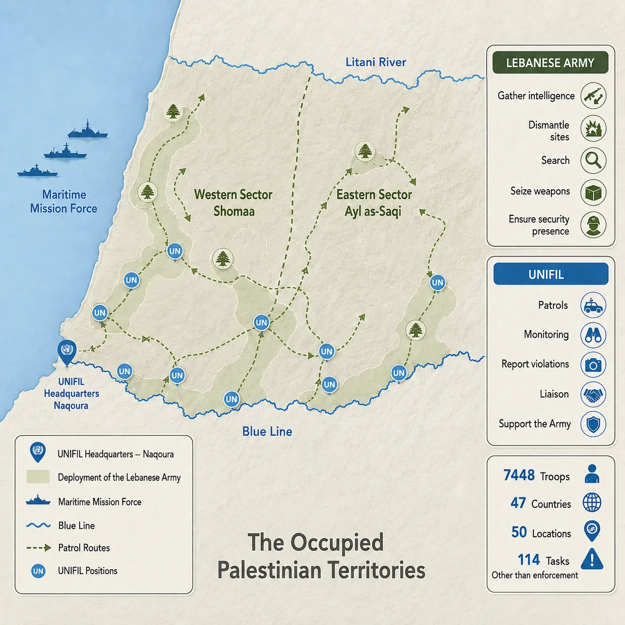
Since 2007, UNIFIL has run a tripartite mechanism that includes officers from the Lebanese Army and the Israeli occupation army under the chairmanship of the commander of the international force. The meetings address violations, military movements, and incidents near the Blue Line, and provide channels of communication when tensions rise.
The ceasefire agreement of Nov. 27, 2024, added a monitoring mechanism led by the United States with French participation, and then the tripartite framework signed on June 26, 2026, established the Lebanon-Specific Military Coordination Group to accompany the withdrawal of occupation forces and the army’s takeover of the agreed areas.
There remains a gap between the deployment of forces and full control over weapons. In the UN secretary-general’s report issued on March 11, 2026, UNIFIL recorded “unauthorized weapons” in the area between the Blue Line and the Litani on 114 occasions, including 73 unguarded facilities or depots.
The average monthly operational activities of UNIFIL fell from 13,750 activities between Feb. 21 and June 20, 2024, to 6,835 activities between Oct. 21, 2025, and Feb. 20, 2026, due to fighting, unexploded ordnance, threats, and restrictions on movement.
Reports before the war’s expansion recorded the presence of unlicensed firing ranges, weapons, and military sites, along with obstacles that hindered UNIFIL’s access to sites linked to tunnels and security incidents. They also documented the continuation of Israeli air sorties, crossings of the Blue Line, and control over northern Ghajar.
South of the Litani thus continued to witness a broad deployment of the army and UNIFIL, alongside weapons, military positions, and violations that run counter to the security arrangement set by the resolution.
From the 2024 agreement to the 2026 pilot zones
The ceasefire agreement linked the withdrawal of occupation forces to the deployment of the Lebanese Army and the dismantling of military facilities not belonging to the state south of the Litani.
After “Israel” kept its forces at five points inside Lebanese territory, the Cabinet tasked the army with preparing a plan to confine arms to the hands of the state, then the army announced progress in its first phase and the expansion of its operational control inside the sector, with the exception of sites where occupation forces remained and with work continuing on tunnels and unexploded ordnance.
Field conditions changed with the expansion of the Israeli incursion during the 2026 war. Reuters quoted informed officials as saying that Israeli deployment maps defined a strip ranging from 5 to 10 kilometers deep in some sectors, amid demolition operations and the prevention of residents from returning.
This deployment brought villages and roads within the Lebanese Army and UNIFIL area of work into the occupation’s military control zone or under its fire, making the army’s advance dependent on a prior or simultaneous Israeli withdrawal.
The US-Lebanese-Israeli arrangements then launched the idea of “pilot zones,” under which the army would assume exclusive control over areas from which occupation forces withdraw, while excluding non-state armed actors.
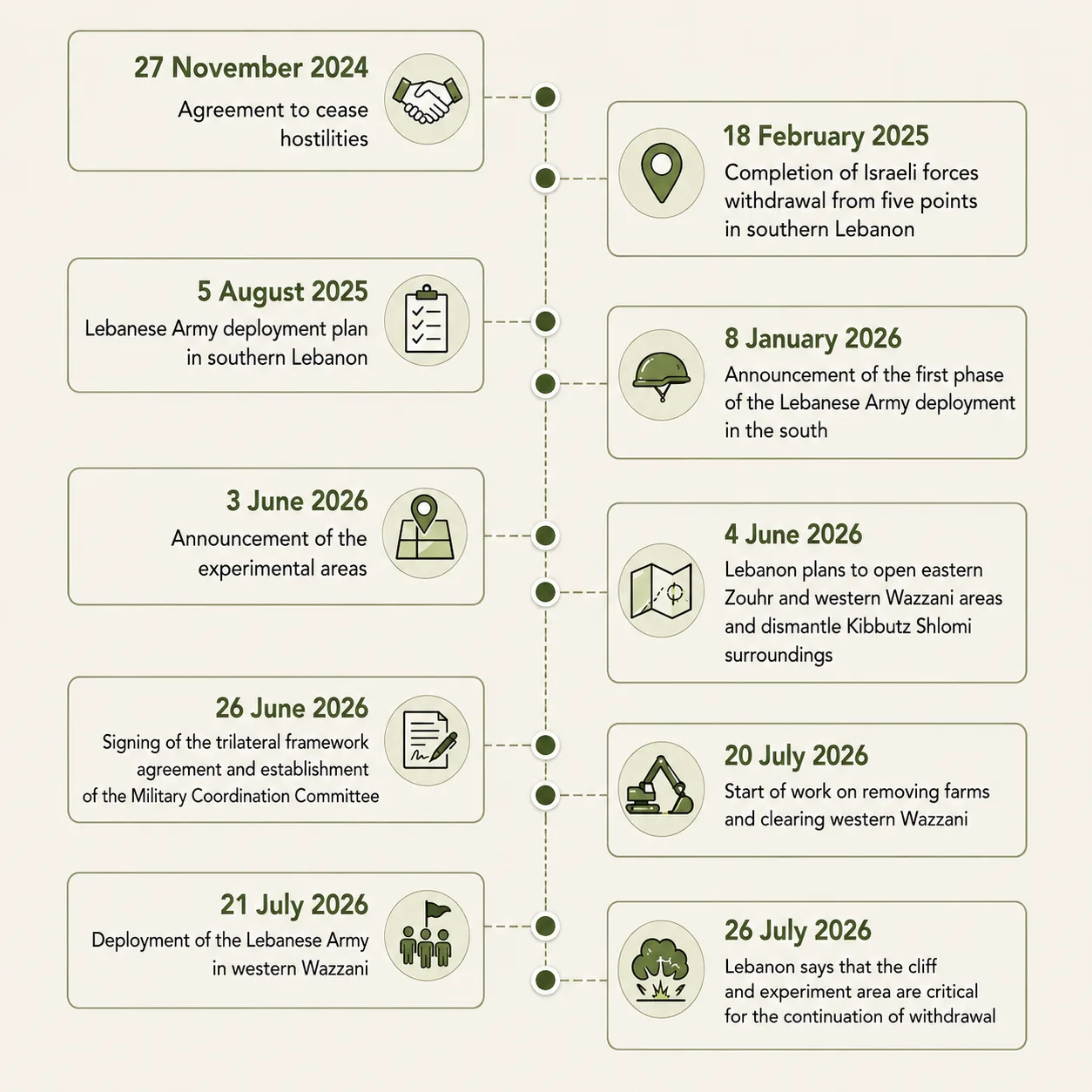
The tripartite framework left the timing of withdrawal and the sequence of its phases to subsequent negotiations and field agreements, while the list of areas changed between the initial Lebanese proposal and the start of implementation without any published official explanation. The first phase included Froun, Srifa, and Zawtar al-Gharbiya.
Froun and Srifa are south of the Litani, while Zawtar al-Gharbiya lies north of the river’s course, expanding the scope of the plan beyond the UNIFIL area of operations.
And the Lebanese Army began deploying in Zawtar al-Gharbiya after occupation forces withdrew from it, carrying out engineering surveys, sweeping operations, and ordnance removal, while Zawtar al-Sharqiya remained outside the handover scope.
The army command later announced that Israeli shelling, gunfire, and bulldozing were obstructing the completion of deployment in the three areas. Implementation also remained tied to the army’s ability to entrench its presence, deal with destruction and ordnance, collect weapons, and dismantle armed positions.
By contrast, Hezbollah Secretary-General Naim Qassem rejected the tripartite framework and linked any discussion of the party’s weapons to the end of the occupation and Israeli attacks, while the government held to the plan to confine arms to the state and extend state authority.
By late July 2026, the army had begun taking over specific areas, while parts of the south remained under occupation control and UNIFIL continued to document “unauthorized weapons.”
The scope of Resolution 1701 remains confined to the area between the Litani and the Blue Line, while the 2026 plan extended to sites north of the river, and its completion remained tied to the withdrawal of Israeli occupation forces and the implementation of the decision to confine arms to the state.
