











هذا التقرير متاح أيضًا بـ العربية
The Turkish fleet surpasses its Israeli counterpart in the number of frigates, submarines, support ships, and maritime patrol platforms, and it is backed by a deployment network stretching from the Aegean Sea to Mersin, Iskenderun, and northern Cyprus.
Israeli power, by contrast, is concentrated in a smaller fleet that has been heavily equipped to protect the coastline and gas fields, and is closely tied to the air force, intelligence, and missile defense systems.
This equation gives Türkiye a greater ability to mass forces, remain at sea, and distribute ships across more than one sector, while the effectiveness of Israeli power rises the closer any confrontation is to Haifa, Ashdod, and the Tamar, Leviathan, and Karish fields.
Around Cyprus, Ankara’s advantage in the north overlaps with the military cooperation network that “Israel” has built with southern Cyprus and Greece, making the location and duration of any clash, as well as the presence of aircraft and submarines, more important than the total number of ships.
An incident reported by Israel’s Channel 12 has brought this debate back to the fore. In a report published on June 25, 2026, it said four large Turkish ships approached to within a few hundred meters of an Israeli missile ship sailing west of Cyprus during an exercise linked to cooperation with the island and Greece.
Details of the incident remained confined to the channel’s account, which used the term “destroyers” to describe the Turkish vessels. The report also omitted a specific date for the incident, the names of the ships, their images, and navigation data, but it revived comparisons between the two sides’ naval power.
A larger Turkish fleet and a concentrated Israeli force
Türkiye has a larger and more diverse naval force than its Israeli counterpart, with a broader number of frigates, corvettes, and submarines, in addition to landing and support ships and maritime patrol aircraft.
The number of ships on record does not necessarily reflect the size of the force actually ready for action, after two Yavuz-class units were transferred to testing and training duties, while the I-class frigates continued trials and outfitting through the summer of 2026.
By contrast, “Israel’s” surface fleet is concentrated in a smaller number of missile ships and corvettes, led by the Sa’ar 6 vessels, whose operational qualification was completed in December 2023.
These ships combine sensing, air defense, and anti-missile capabilities on a single platform, in a design primarily tied to protecting gas fields and offshore facilities. That concentration increases the value of each individual Israeli vessel, but it also makes the distribution of ships between protection, patrols, and combat readiness more sensitive whenever any ship is taken out of service.
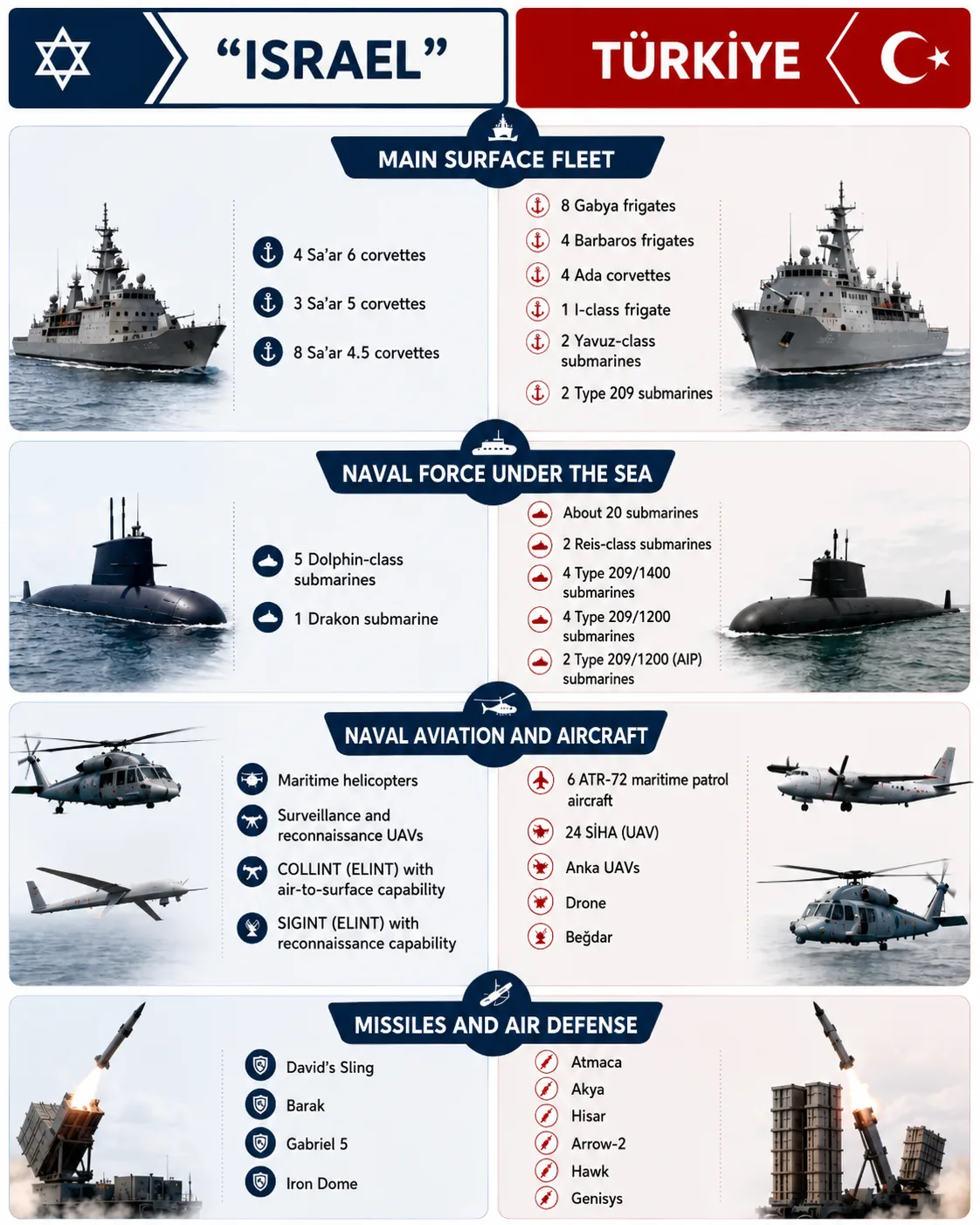
The numerical gap also widens below the surface. Türkiye’s submarine force assigned to combat missions includes about 12 submarines, among them the first two Reis-class units equipped with air-independent propulsion. That figure refers to submarines listed within the combat force, while the number actually ready to sail changes according to maintenance and training schedules.
As for “Israel,” it has five operational submarines from the Dolphin family, while the sixth submarine, Drakon, has yet to enter confirmed active service. The ambiguity surrounding the armament and strategic missions of Israeli submarines gives each unit a deterrent value that exceeds the publicly declared numbers.
Türkiye reinforces its numerical superiority with ships capable of transporting troops, helicopters, and drones, and of supplying naval formations far from ports, strengthening its ability to deploy and remain at sea during extended operations.
This advantage becomes especially important when Ankara distributes its forces between the Black Sea, the Aegean Sea, and the eastern Mediterranean, as it needs support ships that allow naval formations to operate for longer periods and over greater distances.
Türkiye’s defense industries are moving to reduce the fleet’s dependence on foreign systems by producing missiles, torpedoes, radars, and combat management systems domestically.
That path has increased Ankara’s ability to modernize older ships and manage their maintenance and munitions, even as part of the surface fleet still relies on hulls dating back decades and requiring growing resources to maintain readiness.
“Israel,” meanwhile, has focused its investments on increasing the density of sensing and interception systems aboard Sa’ar 6 ships, through systems capable of detecting aerial and maritime targets and dealing with missiles and drones, alongside anti-ship missiles.
The C-Dome system recorded its first publicly announced naval combat interception in April 2024, while the Israeli occupation army announced in February 2025 that it had conducted an operational test of the Gabriel 5 missile. This package serves a defensive doctrine tied more to a limited coastal area and high-value energy facilities than to building a widely deployable fleet.
Türkiye’s advantage is also clear in naval aviation directly subordinate to the navy, through patrol aircraft equipped for surveillance, reconnaissance, and anti-submarine warfare, alongside a fleet of naval helicopters. These platforms give the Turkish navy an independent ability to search for and track submarines and escort ships without relying entirely on air force units.
By contrast, “Israel” relies on integrating helicopters, drones, and aircraft belonging to the air force with ships, intelligence units, and command centers. Publicly announced exercises and operations have shown a high level of coordination among these branches in building the maritime picture, intercepting drones, and identifying targets.
As a result, Türkiye leads in the number of organic maritime patrol and reconnaissance platforms, while Israeli power rests on integrating its smaller fleet into a broader air and intelligence system.
This structure gives Türkiye an advantage in massing forces, deployment, and carrying out independent naval missions for longer periods, while the effectiveness of the Israeli fleet rises when it operates near its shores and under the cover of the air force, intelligence, and air defense.
The impact of the numerical gap remains tied to the location and duration of any confrontation, because numbers favor Türkiye in extended operations, while the density of systems and inter-service integration allow “Israel” to offset part of the gap within its nearby maritime sphere.
Geography distributes power between the two sides
Türkiye’s advantage in the eastern Mediterranean rests on a broader network of bases and ports, stretching from Aksaz on Türkiye’s southwestern coast to Mersin and Iskenderun near the eastern basin, giving the Turkish navy a greater ability to move ships between more than one sector and support larger vessels.
By contrast, “Israel” relies on Haifa and Ashdod as its two main naval centers for protecting the coast and gas fields, while Atlit remains the base for naval special forces, and Eilat lies in a separate theater in the Red Sea.
Northern Cyprus carries particular weight in Turkish calculations, because the ports of Famagusta and Kyrenia give Ankara access and support points that can be expanded in times of crisis, without rising to the level of a permanent naval base comparable to Aksaz or Iskenderun.
The same applies to Turkish air deployment in the north, which included a temporary deployment of F-16 fighter jets and air defense systems during March 2026, while its permanent continuation remained unresolved.
The following map shows the distribution of the main bases and ports and maritime access lines between the Turkish coast, Cyprus, the Syrian coast, and Israeli ports, along with gas fields and the main points of friction and training around the island.
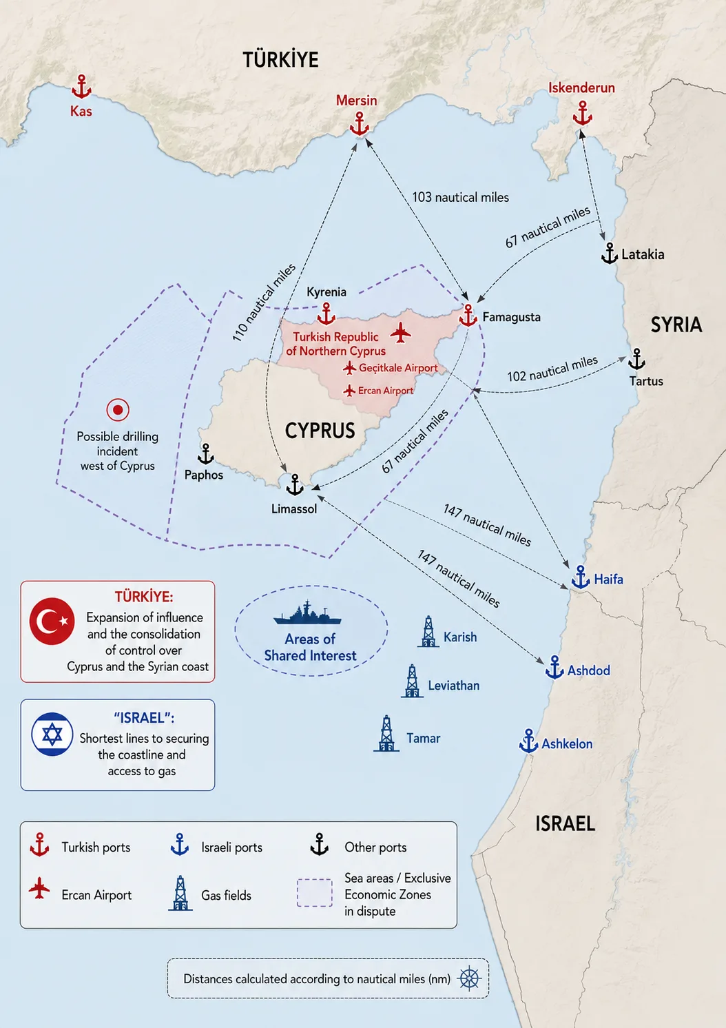
Maritime distances show that Türkiye enjoys a clearer advantage in northern Cyprus and along the Syrian coast, as Mersin and Iskenderun appear closer to Famagusta, Latakia, and Tartus, while distances become relatively more balanced as the comparison shifts toward southern Cyprus.
Haifa and Ashdod give “Israel” shorter lines to the coast and gas fields, increasing response speed in nearby defensive missions, but placing a greater burden on the small Israeli fleet when distributing ships between protection, patrols, and combat readiness.
The picture grows more complicated because of the Greek islands, Cyprus, and the surrounding airspace, as Ankara is forced to distribute part of its power between the Black Sea, the Aegean Sea, and the eastern Mediterranean.
By contrast, “Israel” benefits from a growing network of military cooperation with Greece, Cyprus, and the United States that provides training, information-sharing, and experience in joint operations around the island, without automatically meaning direct combat participation in any confrontation with Türkiye.
The main points of friction in this theater are tied more to energy and sovereignty than to ship movements alone. “Israel” is trying to protect the Tamar, Leviathan, and Karish fields as strategic facilities, while Türkiye views the continental shelf and exclusive economic zone around Cyprus as an extension of the sovereignty dispute and the rights of Turkish Cypriots.
From the Mavi Marmara crisis in 2010, through the escalation of Turkish drilling near Cyprus in 2019, to tensions linked to exercises and air and naval deployments around the island in 2025 and 2026, Cyprus, the gas fields, and maritime access lines have become the clearest center of competition between the two sides.
How is “Israel” trying to narrow the gap?
The Israeli plan relies on increasing the combat value of each ship and linking it to the air force, intelligence, and missile defense. This is evident in the “Sa’ar 6” ships, which combine an advanced radar, interception systems, anti-ship missiles, and the ability to operate helicopters, within a mission focused on protecting gas fields and the exclusive economic zone.
All four ships had entered full operation by December 2023, and the C-Dome system recorded a combat interception in April 2024, while “Barak” missiles also became part of the ships’ capabilities.
These systems increase the ability of a relatively small corvette to deal with missiles, drones, and aircraft and to protect a specific offshore facility, helping “Israel” offset part of the numerical gap within its immediate coastal range.
“Israel” is also working to replace its aging “Sa’ar 4.5” ships through the Reshef project. In December 2024, the Defense Ministry signed a contract worth about 2.8 billion shekels, or roughly $780 million, to purchase five ships from Israel Shipyards.
Construction of the program’s first units and steel cutting began in February 2025, with the first ship scheduled for delivery about three and a half years after construction started, and the program set to be carried out over roughly six years.
That means Reshef remains outside the balance of power in the summer of 2026, with its expected entry beginning around 2028, even as the project reflects “Israel’s” direction toward replacing older ships with more capable platforms while maintaining a fleet size close to the current one.
The same trend is repeated in submarines, as Drakon represents a new phase in the Dolphin program, but its operational status has remained publicly unresolved. “Israel” is also moving ahead with the Dakar submarine program to renew the fleet over the next decade, giving it long-range strategic capability, while the confirmed ready force in the summer of 2026 consists of five submarines.
The partnership with Greece, Cyprus, and the United States forms an additional layer in this compensation plan, as “Israel’s” transfer in 2021 to the US Central Command area expanded exercises and coordination with the US Fifth Fleet.
Exercises with Greece and Cyprus have also made it possible to operate in areas farther from the Israeli coast and to train in anti-submarine warfare and building a shared maritime picture.
These partnerships provide communications, training, reconnaissance, and greater capacity for information-sharing. Whether they translate into direct military participation in a confrontation with Türkiye, however, remains tied to the decisions of the states concerned and to the nature, location, and duration of the clash. The cooperation gives “Israel” important operational depth around Cyprus, without automatically adding Greek or US ships to its combat inventory.
But the Israeli plan faces constraints tied to fleet size and the cost of platforms and munitions. Each Sa’ar 6 ship carries significant weight in protecting offshore facilities, and taking one vessel out for maintenance or having it damaged increases pressure on the remaining ships. Protecting gas fields also requires continuous patrols and a stockpile of interceptor missiles, especially under simultaneous missile and drone attacks.
Türkiye faces different constraints, as multiple fronts distribute its power between the Black Sea, the Aegean Sea, and the eastern Mediterranean, limiting its ability to keep most of the fleet in one sector for a long period.
Some frigates also still rely on old hulls despite upgrades to their systems, and national frigate and submarine programs need years before they can replace older units. Offsetting that, Türkiye possesses a broader naval and missile industrial base, and a greater ability to build ships, submarines, and support vessels domestically.
Assuming a limited confrontation near northern Cyprus or around exploration ships, Türkiye begins with an advantage derived from the proximity of Mersin and Iskenderun and the possibility of using northern ports, in addition to a larger number of ships, submarines, and maritime patrol aircraft. It can also send several vessels into the area and create a presence that raises the cost of any approach by a research ship or a small Israeli force.
The equation becomes more balanced in southern and western Cyprus, where distances from Haifa and Mersin become relatively similar, and reconnaissance, electronic warfare, and air cover determine which side can detect the other, track its movement, and manage the engagement. The nature of relations with Cyprus and Greece also affects aircraft movement and the use of airspace and ports.
Around Israeli offshore facilities, “Israel” starts from a stronger position, as the “Sa’ar 6” ships operate near their bases, command centers, and the air force, and their systems were designed to protect gas fields and intercept missiles and drones.
Israeli aircraft can quickly reach the nearby maritime zone, while Turkish forces in this scenario would be operating farther from their bases and under dense aerial and intelligence surveillance.
That advantage, however, remains tied to a limited confrontation in terms of time and fronts. A prolonged war of attrition would strain the number of Israeli ships and the stockpile of interceptor missiles, and give Türkiye the opportunity to benefit from its number of platforms, support ships, and ability to rotate units.
In a broader confrontation involving aircraft, submarines, and missiles, Türkiye would enter with greater numerical, industrial, and logistical weight, and could rotate more ships and submarines if it eased its commitments in the Black Sea and the Aegean. “Israel,” meanwhile, would enter with air power close to its shores, dense naval air defense, and a command-and-intelligence network that increases the small fleet’s ability to detect targets and distribute fire.
The length of any expected confrontation favors Türkiye because of its number of platforms, support ships, and ability to rotate forces, while short distances and integration with the air force favor “Israel” in close, rapid engagements.
Submarines remain a difficult factor to measure for both sides, because their deployment locations, armament, and rules of use are subject to secrecy, and the presence of a single submarine in a decisive sector could restrict the movement of several enemy ships.