







هذا التقرير متاح أيضًا بـ العربية
Israeli occupation forces have been building a military route known as “Sufa 53” in the occupied Syrian Golan since 2022. Initially a road for tanks and other military vehicles, it has grown to include trenches, earthen berms and observation points.
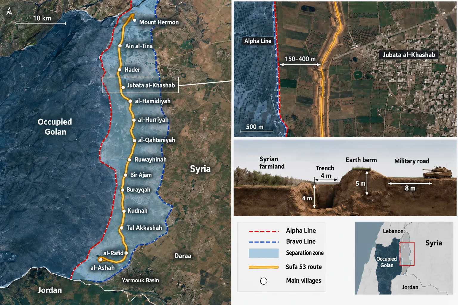
The route stretches from the slopes of Mount Hermon in the north, through the Quneitra countryside, to the area adjoining the Yarmouk Basin in the south. It cuts through farmland and grazing areas belonging to Syrian villages east of the occupied Golan.
The danger lies in the project’s location within the area bounded by the Alpha and Bravo lines under the 1974 disengagement agreement. This area remained under UN monitoring for decades before Israeli occupation forces advanced into it after the fall of Bashar al-Assad’s regime and established permanent military positions.
On 4 October 2026, bulldozers and military vehicles reached areas west of the village of al-Asha and south-west of the town of al-Rafid. After four years of gradual excavation and bulldozing in the northern and central sectors, they began extending the trench and road towards southern Quneitra and the Yarmouk Basin.
The route is now approaching a stretch where the separation zone narrows to less than a kilometre, near the point where Quneitra, Daraa, the occupied Golan and the Jordanian border meet.
The route of “Sufa 53”: from Mount Hermon to the Yarmouk Basin
Work began in northern Quneitra in mid-2022. Syrian field reports at the time documented incursions by Merkava tanks and military bulldozers west of Ain al-Tineh, near the slopes of Mount Hermon.
The road subsequently extended south towards Hader, Jabata al-Khashab, al-Hamidiyah and al-Hurriya, then al-Qahtaniyah, Ruwayhinah, Bir Ajam, Bariqah, Kudnah and Tal Akasha, before reaching the southern sectors where bulldozers advanced during 2026.
On 12 March 2023, the Israeli military’s website published details of a new route being built on the Syrian front. It said the engineering unit of Division 210, responsible for the Golan front, had carried out the work alongside armoured forces from the 53rd Battalion, “Sufa,” part of the 188th Armoured Brigade.
The battalion’s name and number match the name used in Syrian media for the project. The military’s publications, however, offer no official explanation for why the road itself is called “Sufa 53.”
Lieutenant Ariel Ben Dor, commander of an engineering equipment platoon in Division 210, said the road was designed for tanks to use in daily operations and combat. He described it as part of a wider network of routes being prepared along the Alpha line.
On 23 May 2026, the Syrian Record Center, which monitors Israeli military incursions in Syria, mapped the road from west of Ain al-Tineh in the north to south of Sayda al-Hanout. Its route passed through Jabata al-Khashab, al-Hamidiyah, al-Qahtaniyah, Ruwayhinah, Bir Ajam, Bariqah and Kudnah.
When bulldozing resumed in October, the route extended to areas west of al-Asha and south-west of al-Rafid, heading towards the Yarmouk Basin and the southern edge of the separation zone.
The fortifications vary along the route. In some sectors, the military road is about eight metres wide, with earthen berms nearly five metres high, deep trenches, observation points and positions through which troops and vehicles can pass.
Elsewhere, the trench forms the main fortification. Excavated soil is piled into a high berm that blocks visibility and impedes the movement of people and vehicles from one side to the other.
The map accompanying the 1974 disengagement agreement shows why the route’s location is sensitive. The agreement established line “A,” or Alpha, to the west, behind which Israeli occupation forces are stationed, and line “B,” or Bravo, to the east, for the deployment of Syrian forces.
Between them lies the “area of separation,” monitored by the UN Disengagement Observer Force, or UNDOF, and remaining under Syrian civil administration. A subsidiary line, known as “A-1”, lies near the city of Quneitra.
The separation zone runs for about 80 kilometres, from the vicinity of Mount Hermon in the north to the Yarmouk Basin in the south. Its width varies considerably: it spans several kilometres in the central sector, then gradually narrows southwards to less than a kilometre in some places.
Alpha and Bravo are therefore not parallel lines a fixed distance apart. Nor does “Sufa 53” remain a fixed distance from the Alpha line along its entire route.
Measurements and field accounts indicate that sections of the trench and road extend east of the Alpha line. In parts of the Quneitra countryside, the distance ranges from about 100 to 400 metres, while other estimates record deeper incursions and engineering works at some locations.
In autumn 2024, the Syrian Network for Human Rights estimated that some Israeli movements had reached nearly two kilometres into Syrian territory. Other monitoring recorded bulldozers working between 150 and 200 metres inside it around Jabata al-Khashab.
From a tank road to infrastructure for an entrenched occupation
When construction began in 2022, the Israeli government cited the Iranian presence and Hezbollah activity in southern Syria to justify increased surveillance and military fortifications on the Golan front.
A former commander of the local “Knights of the Golan” faction, which received Israeli support during the years of the revolution, linked construction of the route to the expansion of that presence towards the area adjoining the occupied Golan.
From the outset, the military also intended the road to give its forces greater freedom of movement. In March 2023, officers from Division 210 said the new routes were designed for tanks to use both daily and in combat. The plan was to prepare the entire front for armoured forces to move along the Alpha line, rather than depend on a limited number of known roads.
After Operation Al-Aqsa Flood on 7 October 2023, the Israeli military added another layer of fortifications on the Syrian front. On 4 November 2024, it announced the “New East” project, comprising deep trenches, earthen berms and barriers designed to obstruct vehicles.
That day, Major Shlomi, an engineering officer working with Division 210 forces, explicitly linked the project to the use of bulldozers to breach the fence surrounding the Gaza Strip on 7 October. “New East” covers some of the same areas as “Sufa 53” and uses the same engineering features: trenches, berms, roads and crossing points.
In August 2026, the Hebrew newspaper Yedioth Ahronoth reported that about 80 per cent of the “New East” trenches had been completed between Majdal Shams in the north and the border triangle in the south. The trenches were about four metres deep and four metres wide, with crossing points kept under surveillance and covered by fire.
The Israeli military’s publications continue to distinguish between the two names. “Sufa 53” refers to a route that began nearly two years before “New East” was announced.
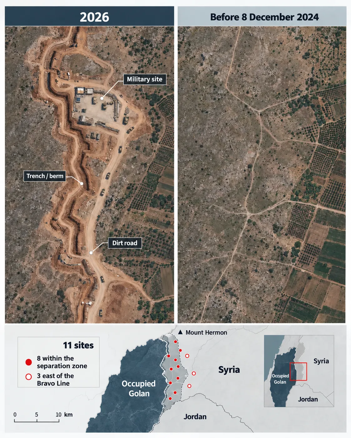
The most significant change came on 8 December 2024, when Israeli occupation forces advanced into the separation zone after the fall of the Assad regime. They took control of the Syrian side of Mount Hermon, then expanded their deployment across the Quneitra countryside and western Daraa, establishing permanent positions inside Syrian territory.
In March 2026, UN Secretary-General Antonio Guterres counted eight Israeli positions inside the separation zone and three more in the area of limitation on the Syrian side of the Bravo line. Road construction and the building of berms and fortifications were continuing.

After December 2024, the Israeli deployment shifted from limited incursions to permanent military positions inside Syrian territory
By September 2026, the Independent International Commission of Inquiry on Syria said Israeli military activity in southern Syria had become “increasingly sustained and entrenched,” documenting a network of temporary checkpoints, permanent military installations, patrols and raids during visits to Quneitra and Daraa.
The commission also described the expanded Israeli presence inside Syrian territory as a “belligerent occupation”. It said that, by midyear, it had identified 49 Syrians, including two children, who had been arrested by occupation forces inside Syria and likely transferred to territory controlled by “Israel.”
Muath al-Abdullah, Middle East research manager at the Armed Conflict Location & Event Data Project, or ACLED, said construction of the military road in Quneitra helped consolidate a long-term military foothold. Agricultural areas had been turned into a corridor for troop movements, reconnaissance and operations.
Al-Abdullah linked the road to the network of military facilities, roads and services that occupation forces had established since December 2024. He argued that continued construction indicated plans extending beyond a temporary deployment.
Israeli statements also became more explicit. On 25 August 2026, Defence Minister Israel Katz said forces would remain on Mount Hermon and in what the government calls the “security zone” for as long as it perceived a threat.
Israeli Prime Minister Benjamin Netanyahu entered Mount Hermon the following month and spoke of what he called the “continuation of military control to prevent hostile forces from entrenching” near the occupied Golan.
— Noon Syria (@NoonPostSY) September 10, 2026
Restrictions on land, water and movement
Villages began to feel the effects of “Sufa 53” in the earliest stages of construction, as bulldozers crossed land used for farming and grazing. Restrictions widened as trenches and berms were built and military patrols spread.
In March 2023, farmers reported being prevented from reaching parts of their land. A shepherd was arrested near al-Hurriya, while in other incidents civilians approaching areas where occupation forces had deployed were fired upon.
As the trench extended, the affected area grew beyond the land bulldozed for the road itself. The berm and trench cut off farmland and grazing areas from villages east of the route.
On 6 May 2026, Mohammad al-Saeed, media director in Quneitra province, said a local assessment put the damaged land in the northern and central countryside at about 12,000 dunams. Mohammad Mazen Meryoud, the mukhtar of Jabata al-Khashab, said the project had affected about 7,000 dunams of the town’s land.
In Bariqah, a farmer told Syria TV that the earthen berm had cut off nearly half his land, a plot of about five dunams planted with apples and apricots. He could no longer reach more than 100 trees on which he depended for income.
Elsewhere, berms blocked shepherds’ routes to pastures. To move their livestock, they had to use the corridors left by troop positions and the new trenches. Residents also reported effects on water drainage, as trenches and berms cut through channels that rainwater had followed for years.
After heavy rain at the end of March 2026, sections of earthen berms collapsed, sending water towards land and homes in Jabata al-Khashab, Ain al-Bayda and Ofaniya. The water reached fields planted with wheat, broad beans and barley. Farmers reported increased soil erosion as drainage patterns changed.
Beyond the land isolated by “Sufa 53” and its accompanying trenches and berms, the occupation brought further restrictions on residents of Quneitra and western Daraa after December 2024. Israeli forces established bases and checkpoints and fenced off land outside the road’s immediate route.
On 28 April 2026, Human Rights Watch documented occupation forces fencing off farmland, grazing areas and water sources in newly occupied areas, bulldozing orchards and forested land, preventing families from accessing their livelihoods, and establishing military facilities near populated areas.
These findings place the effects of “Sufa 53” within the broader Israeli military control of land and residents’ movement.
In a field study published on 26 March 2026, Kholoud Helmy, a researcher at the Tahrir Institute for Middle East Policy, traced how checkpoints and patrols had become part of daily life in Quneitra and western Daraa after the regime’s fall. They affected fields, routes to work and travel between villages.
Residents interviewed by Helmy described having to weigh the risks of reaching fields, schools and water sources because of new patrols and checkpoints. Their accounts reflect the effects of “Sufa 53” on villages along its route.
Throughout 2026, the Security Council also received repeated UN briefings on residents being denied access to agricultural land and facing restrictions on movement in Quneitra and Daraa, alongside raids, searches and temporary checkpoints.
In one briefing, the office of the UN special envoy cited complaints from Hader residents about repeated raids, restricted access to farmland and intimidation of civilians. These practices have become associated with the military deployment extending on both sides of the separation lines.
When bulldozers reached areas west of al-Asha and south-west of al-Rafid on 4 October 2026, excavation entered another sector whose residents depend on farming and grazing, on the route towards the Yarmouk Basin.
That day, the Syrian Foreign Ministry condemned the completion of “Sufa 53”, calling it a violation of the disengagement agreement. The UN continues to regard the presence of occupation forces inside and east of the separation zone as contrary to the 1974 agreement and calls for their return to the positions they held before December 2024.
