





هذا التقرير متاح أيضًا بـ العربية
“Which of these two maps I have shown you will shape our future? Will it be the blessing of peace and prosperity for Israel, our Arab partners, and the rest of the world? Or will it be the curse in which Iran and its proxies spread chaos and destruction everywhere?” Benjamin Netanyahu, 2024.
Naturally, talking about the map and the struggle over it or over its interpretation and meaning may seem self-evident in the context of wars, military conflicts, and the history of colonialism. But this discourse has usually remained confined to elite circles of politicians and historians, with most of its debates unfolding behind the scenes rather than in full public view.
With Benjamin Netanyahu’s rise to the premiership in Israel, however, the use of the map to conceptualize and market the Arab-Israeli conflict from an Israeli perspective took on a different and far more visible character. Netanyahu is perhaps one of the political leaders who has used maps most extensively as a rhetorical and visual tool whether in speeches at the United Nations, inside the Knesset, or even before the US Congress.
Those maps were often accompanied by confident gestures and pointing fingers laden with connotations of dominance and control, making the map part of the political performance itself, not merely an illustrative aid.
With Netanyahu, we are invited to engage more deeply in reading cartographic discourse and trying to deconstruct it and understand its symbolic structure. Every map he displayed carried its own political semiotics, expressing the Middle East from an Israeli perspective and at times even seeking to reshape it symbolically and politically.
At first glance, Netanyahu’s maps appear highly simplistic, dividing the world in schematic fashion through colors or verbal labels. But beneath that lies a more complex vision deliberately concealed behind this intended simplification. Netanyahu’s map functions as a code with two levels of meaning: a simplified populist message aimed at winning public sympathy and directing perception, and a more layered message serving his partisan and ideological goals at home while sending strategic signals to allies and adversaries abroad.
More broadly, the map has occupied a central place within the Zionist project, and many milestones in the history of the conflict were built around it. At times, Israeli leaders treated their maps with a degree of sanctity that made them their exclusive preserve unlike Netanyahu, who has made a habit of displaying his maps publicly and boasting about them.
Before turning to Benjamin Netanyahu’s cartographic discourse and its political semiotics, there is first a need to understand the centrality of the map in the Zionist project and the theoretical meaning of cartographic discourse. From that starting point, this paper seeks to trace a simplified chronology of Netanyahu’s contemporary maps, before concluding with an attempt to unpack the psychological impact and the political-psychology messages those maps carry to their target audiences whether the audience he seeks to win over or the adversary he seeks to summon and provoke.
Concealed maps … and confiscated maps
“Shattered Dreams of Peace: The Road to Oslo” was the title of the film produced by the US network PBS in 2002 as part of its “Frontline” series, known for its ability to reach decision-makers and witnesses to pivotal moments and document their accounts of what they lived through or helped shape. At first glance, the film may seem like merely a historical document about a phase of negotiations between the Zionist entity and the Palestine Liberation Organization under US mediation.
But its details also reveal deeper elements that helped shape this conflict and continually reproduce it chief among them, the map.
“I was authorized to show the Palestinians a sketch. It wasn’t a map, just a general sketch.” With these words, Israeli negotiator Oded Eran described the nature of what he had been allowed to present during the negotiations, while US envoy Dennis Ross recounted the scene from another angle, saying: “The Palestinians kept saying, ‘Show us a map, we need to see a map.’ But Oded had not been authorized by Barak to show them one, only a sketch.”
This deliberate confusion was not unique to former Israeli Prime Minister Ehud Barak. In one of the most recent documentaries on the Palestinian-Israeli conflict “Israel and the Palestinians: The Road to October 7,” produced by veteran British documentarian Norma Percy for the BBC a similar account appears, proudly presented by former Israeli Prime Minister Ehud Olmert as he speaks of his “historic offer,” which, according to his version, could have ended the Palestinian issue.
Olmert says he told Condoleezza Rice that Israel would withdraw from 95 percent of the West Bank, that the Arab part of Jerusalem would be the capital of the Palestinian state, and that the holy basin would be administered under a joint trusteeship including Saudi Arabia, Jordan, Palestine, Israel, and the United States under the auspices of the UN Security Council.
In theory, the offer could have opened a different path for negotiations. But the dilemma resurfaced once again with the map itself. In the same program, Olmert showed the map of his proposal for the first time more than 15 years after leaving office, having previously refused to hand it over to his Palestinian counterpart Mahmoud Abbas before it was signed.
Abbas needed to show the map to his cartography expert for study, but Olmert refused and instead proposed a closed meeting between the two sides’ map experts a meeting that never took place. Olmert now recalls that moment with sarcasm, saying: “Fifteen years later, I’m still waiting for a phone call from President Abbas.”
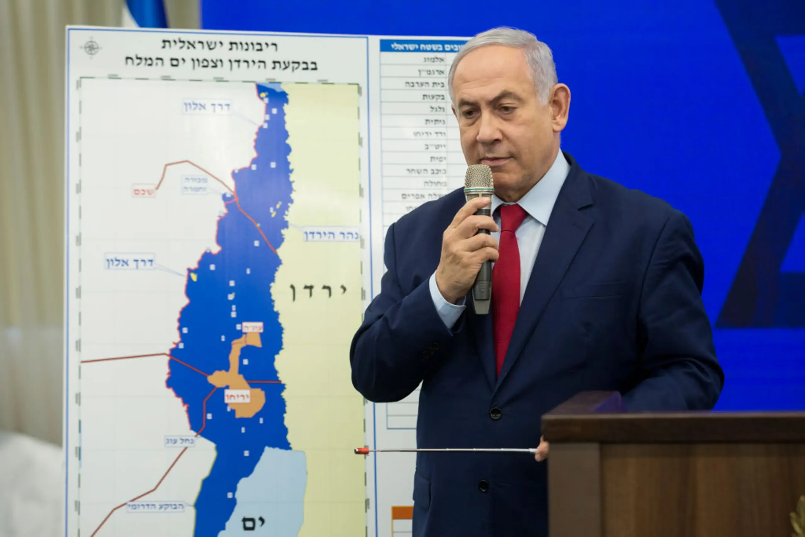
From the other side, Rafiq Husseini, director of President Mahmoud Abbas’ office, recounts the details of that deal, saying: “Olmert presented President Abbas with that map, but told him he could not take a copy of it. How can you sign a map representing the most important agreement for the Palestinian people when you do not know exactly what the map looks like and what conditions surround it? This is not a good agreement. We have to wait for a new prime minister.”
This incident reveals how the Israeli side retained, linguistically and interpretively, the keys to the map its meanings and its boundaries. The map was not merely a negotiating paper, but a tool for monopolizing both knowledge and sovereignty. As the story of Olmert and his “historic” offer suggests, this appears to be a recurring feature in the history of the Zionist project, one shared by a number of its founders and leaders across different stages.
A similar significance appears in another incident recounted by Murad Ghaleb, Egypt’s former foreign minister, in his memoir “With Abdel Nasser and Sadat: Years of Victory and Days of Hardship.” Ghaleb notes that Romanian President Nicolae Ceaușescu visited Egypt in February 1972 and offered to mediate between Anwar Sadat and Golda Meir, then Israel’s prime minister, an offer Sadat accepted.
But the more important development came in 1977, when Ceaușescu met Israel’s new prime minister, Menachem Begin, who presented him with a road map for peace accompanied by maps on which all the city names and areas were written in Hebrew, before inviting Sadat to review them.
Sadat and Murad Ghaleb agreed that Begin’s presentation was not sincere, and that what he actually meant by the “Hebraization” of the map was to deny the possibility of an independent Palestinian state under any circumstances. Hebraization here was not merely a linguistic matter, but an attempt to redefine the place itself, erase its Arab narrative, and replace it with another. The Hebraization of maps necessarily requires confiscating their Arab counterpart where possible, and this at times became a practical objective for the Israeli army itself.
In his book “The Palestine Laboratory,” researcher Antony Loewenstein recounts part of this story. He says that during the invasion of Beirut in 1982, one of the targets Ariel Sharon’s army paid special attention to was the Palestine Liberation Organization’s research center. There were no weapons, ammunition, or fighters in the center, but rather something the Israelis considered more dangerous: books about Palestine, old records, land ownership documents belonging to Palestinian families, photographs of Arab life in Palestine, historical records documenting Palestinian presence, and, most importantly, maps of Palestine before 1948 showing Arab villages, many of which were erased after Israel’s establishment.
The research center, in Loewenstein’s description, was like a vessel carrying Palestinian memory and testimony to its historical existence. From this angle, it becomes understandable why Sharon sought to seize it. This mentality can even be sensed in the phrases Israeli soldiers left on the center’s walls after storming it, including: “Palestinians? What is that?”
The Israel Exploration Society
The Zionist movement was among the earliest movements to use the map as both a propaganda tool and a national symbol. Since the early years of the British Mandate in the 1920s, the map of Palestine or “Eretz Yisrael” in Hebrew appeared on posters, stamps, and various Zionist symbols. It was surrounded by an almost religious aura, and in some Zionist rituals it came to resemble a sacred object.
Perhaps the most famous example is the map drawn on the Zionist donation box known as the “Blue Box,” which played a pivotal role in acquiring Palestinian land, and later expanded its role to include afforestation projects and the expansion of green areas inside Israel through the creation of forests across the country.
The most prominent official behind this project, under assignment from David Ben-Gurion, was engineer Joseph Weitz, whose name became associated with projects to displace Palestinian peasants and seize their land. His granddaughter addressed his biography and settlement project in a documentary film that the writer of these lines has previously discussed on another occasion.
In the Zionist conception, confiscating original maps or reshaping them appears to be an essential part of the struggle over place and memory. The power of mapmaking, both rhetorically and practically, is manifested through practices of showing and concealing, highlighting and marginalizing especially with regard to place names and their meanings.
Milène Julliard, a researcher in Jewish studies at the University of Bern, notes in her paper “The persistence of silent geographical landscapes in contested territories: The case of the Arabic language in West Jerusalem” that highlighting the place names of one group while excluding the names of other groups from the map is an effective tool for convincing inhabitants of their “natural” entitlement to the land, while at the same time stripping legitimacy from the other side’s narrative and its claim to sovereignty over the same place.
Here we need to pause at length over Julliard’s paper, because it sheds important light on the role of map formation and the names written on it, and the typography used in it in manufacturing Israeli identity by erasing the presence of the other and redefining space visually and linguistically. Milène asks: “How can something that does not appear on the map truly exist?”
From this question, she sets out to understand how maps became a tool for symbolically excluding Palestinians by effacing their spatial and linguistic presence. She argues that the need to erase the other was clearly manifested in place-naming policies within the Palestinian-Israeli conflict, especially with the intensive use of maps and counter-maps.
Zionism treated this idea as one of the core pillars in building Israeli national identity. After 1948, reviving biblical names and writing place names in Hebrew was not merely a step to affirm control over the land; it also became a means of introducing Jewish inhabitants most of them new immigrants to the geography presented to them as a “historic homeland.”
In part, the process was an attempt to produce a reciprocal relationship between the land and its new inhabitants by reshaping space visually, linguistically, and symbolically.
From here, invoking the biblical past and reinscribing it within the natural landscape becomes part of a strategy aimed at entrenching settlement and granting it historical and symbolic legitimacy.
To achieve this goal, the “Israel Exploration Society” was founded in 1949 with the aim of proving the existence of a prior and continuous Jewish connection to the land since biblical times. The society sought to link the production of the Hebrew map to a broader project based on studying the land, its history, and its prehistory, with a focus on settlement and the social and historical relationship between the “People of Israel” and the “Land of Israel.”
In the same context, place-naming committees at both the national and local levels devoted their efforts to reshaping geographic space by changing Arabic site names. The process of Hebraization has continued to this day, whether by reviving old Jewish names or inventing entirely new ones.
Imposing Hebrew names on the land carried a significance that went beyond the administrative or linguistic dimension, as it was presented as an expression of the successful “return of the Jews” to the Land of Israel and an invitation to possess the land both materially and symbolically at once. At the same time, this process involved erasing the Palestinians’ narrative, culture, and spatial memory, as part of a policy approved at the highest levels of the Israeli state.
David Ben-Gurion summed up this vision by saying: “We are obliged to remove the Arabic names for reasons of state. Just as we do not recognize the Arabs’ political ownership of the land, we likewise do not recognize their spiritual ownership and their names.” At this point, we can conclude the extended quotation from Milène Julliard’s paper before moving to another angle of Israeli cartographic discourse.
The map as objective science!
Egyptian journalist Mohamed Hassanein Heikal says in one episode of his Al Jazeera program “A Life Experience” that French President Charles de Gaulle once remarked: “You cannot read history correctly without opening the map.” In invoking this phrase, Heikal aligns, in one way or another, with the classical school that treated maps as objective tools for reading both reality and history.
Among geographers and the general public, cartographic representations long enjoyed a special epistemic status as accurate and neutral sources of truth, as researchers Christine Leuenberger and Izhak Schnell note in their paper “The politics of maps: Constructing national territories in Israel.” In this conception, the natural world can be observed and visually represented directly.
Unlike fields such as psychoanalysis, which deal with internal phenomena difficult to access through direct observation, cartography appeared closer to sciences applicable according to the traditional scientific method, where the map is presented as a reflection of reality more than an interpretation of it.
But this conception of maps did not withstand other critical schools that saw the map not as an innocent reflection of the world, but as a visual discourse carrying within it political and ideological visions and selective decisions determining what should be shown or hidden.
From here, the design of the map itself becomes a political act capable of revealing much about its maker and the authority behind it. This is what geographer Mark Denil affirms in his paper published in 2003 under the title “Cartographic design: Rhetoric and persuasion,” when he says that “maps are designed to carry meaning, to persuade someone of some information or communicate it to them.”
Denil argues that these meanings are built through multiple mechanisms of persuasion, including the graphic complexity of the map, the relationship between visual form and the density of information displayed on its surface, in addition to the way data is arranged hierarchically and how different sets of information interact, crowd one another, or separate within a single page.
What is displayed on the map is not chosen spontaneously, but is determined by the systems of symbols and generalizations used in the design.
This also extends to the map’s typography the texts and names written on it which can create the map’s meaning or completely undermine it. Denil describes this aspect as one of the most complex graphic elements, even though it appears simple at first glance. A word written on a map may carry more than one meaning at the same time, and may become a tool of direction and persuasion no less important than the lines and symbols themselves.
To explain this idea, Denil poses a question that appears technical on the surface but carries a deeper significance: “According to the map, can one drive from Brunswick Street to Lower Water Street via George Street?” He then adds that the real question here is not merely about the route, but about the kind of truth the map presents in the first place, and whether that truth is measurable in absolute terms or is instead the result of the mapmaker’s choices and way of representing reality.
At its core, the analysis of cartographic discourse depends on deconstructing what appears to be a fixed truth and tracing it back to the facts and meanings that produced and shaped it. For Mark Denil, for example, truth is not limited to the map telling me whether it is possible to move from point “A” to point “B.” There is a deeper question about the nature of that truth itself, and about the way the map may lead the viewer to adopt a certain understanding of the world while ignoring other elements within it. From here emerges the role of “critical geopolitics” as an attempt to understand what maps conceal as much as what they reveal.
This aspect occupies a central place in the work of historian and geographer Gerard Toal, who stresses the need to pay attention to the ambiguity and complexity produced by geopolitical discourses and the practices associated with them. Excessive simplification of geopolitical meanings, in his view, often leads to a superficial understanding of conflicts and political geography, while at the same time producing disregard for the victims who live with the effects of this discourse and bear its violence on the ground.
If we want to apply this idea to the Palestinian context, we can pause at the book by researchers Neve Gordon and Nicola Perugini, “Human Shields: A History of People in the Line of Fire.” In their treatment of the way the Israeli occupation army defends its military operations against civilians in Gaza before the international community, the two researchers draw attention to the central role maps and diagrams play in constructing the Israeli narrative.
During Israel’s 2014 assault on Gaza, the army published a large number of maps and illustrations depicting civilian homes and residential areas as sites used by Hamas to hide or rearm. Through this visual representation, civilian space itself was presented as a potentially military space.
From here emerged the concept of “dual use,” which the army employs to justify targeting civilian facilities and places by claiming they simultaneously serve military purposes. Although targeting civilians remains contrary to international law, Israel relies on legal interpretations tied to the principle of “military necessity” and proportionality, allowing the use of lethal force under the pretext that the expected military gains outweigh the harm inflicted on civilians.
This is what the two researchers criticize when they write: “Under such circumstances, the home cannot be a refuge, even when the majority of the inhabitants in the targeted area are in fact refugees, as is the case in Gaza. The re-description of space from a space of life to a space of death is crucial, because it authorizes the Israeli military to distort the meaning attributed to the people living within that space, and to the violence it unleashes.
In other words, the methods of Israeli moral mapping, to borrow the expression of political geographer Derek Gregory, who describes how morally acceptable violence is tied to space, are sharply evident here. The way a place is defined can facilitate the killing of civilians without that constituting a crime.”
For this reason, the map loses its claim to neutrality and objectivity, and the importance of Gerard Toal’s critical geopolitics comes to the fore. In this context, critical geopolitics offers a different approach based on questioning geographic knowledge and perceptions rather than treating them as fixed truths. It does not confine itself to analyzing official discourses, but compares different levels of knowledge production, whether those issued from above such as the state and political, military, and diplomatic elites or those produced by groups under domination, such as refugees, dissidents, stateless people, and populations subjected to violence.
In his readings of Orientalism and geopolitical discourse, Toal explains how different conceptions of the “East” past, present, and future contributed to producing shifting political meanings through spatial metaphors, maps, and the discourses associated with them.
He therefore sees it as necessary for political geographers to question the “transcendent truths” formulated by politicians, decision-makers, and thinkers when producing geographic knowledge that grants legitimacy to one authority’s domination over space.
From this angle specifically, it becomes necessary to understand what Benjamin Netanyahu’s maps present as a complete political discourse that seeks to redefine the region, and then to treat them as material worthy of deconstruction and skepticism, not merely as maps to be read and accepted at face value.
“The biography of a man infatuated with maps”
At first glance, and when looking at Benjamin Netanyahu’s political biography, one might think we are before “the biography of a man infatuated with maps.” In a world filled with maps and posters calling for “Greater Israel,” the youngest son of Benzion Netanyahu grew up. Benzion was one of the most prominent activists in Ze’ev Jabotinsky’s movement and one of his close associates, a movement known as “Revisionist Zionism.”
Jabotinsky had written the song “The East Bank of the Jordan,” which later became a mobilizing slogan for the Betar movement, with each verse ending in the famous line: “The river has two banks … this one is ours, and the other one is ours.” Every time Netanyahu appeared holding a map, he seemed intent on making it reflect the dreams of Greater Israel, with Palestinian presence either erased or reduced to Israeli security conceptions.
With a bold media style and intensive use of visual tools to market his geopolitical vision, Netanyahu consistently succeeded in stirring controversy over the charts, caricatures, and, of course, maps he displayed. Hardly any of his cartographic presentations were free of political or symbolic provocation. In some maps, “Greater Israel” appears while Palestine disappears entirely; in others, Morocco appears without Western Sahara, forcing him to apologize later. He has also displayed maps of secret nuclear sites, alleged “terrorist” networks, and maps signed by Donald Trump.
Tracing this relationship chronologically, journalist Oscar Rickett suggested in his article “Benjamin Netanyahu and maps: A brief history of an enduring love affair” that Netanyahu’s relationship with maps began in his early political youth. In 1990, when he was serving as Israel’s deputy ambassador to the United Nations, he appeared carrying a map on which he had drawn a red frame marking the locations of Palestinian “terrorist movements” that he said threatened Israel’s security.
This cartographic fascination does not stop at using maps in presentations and speeches; at times it extends to drawing them himself. One aspect of this hobby surfaced during the dispute that erupted in 2024 over the Philadelphi Corridor, when Netanyahu entered into a sharp argument with Defense Minister Yoav Gallant over obstructing a ceasefire agreement.
During the discussions, Netanyahu presented the cabinet with maps specifying the shape of the Israeli presence in the Philadelphi Corridor during the first phase of the agreement and demanded that the cabinet vote to approve them. But Gallant accused him of designing those maps in the first place to obstruct the agreement.
According to Gallant, Netanyahu even drew maps different from those adopted by the Israeli ceasefire negotiators in order to achieve that goal.
Netanyahu likes dealing with the world through maps. There, geography appears more pliable to his desires than the political realities on the ground, which do not always proceed according to his will and planning. To many, he seems to have a map for everything, reflecting his conception of Israel’s place in the world an old obsession to the extent that his first book bore the title “A Place Among the Nations: Israel and the World.”
In 2016, during his meeting with Paraguayan President Horacio Cartes in Jerusalem, Netanyahu told reporters: “I would like to reveal to members of the press that there is a large map in my office, and it has been enlarged. It used to represent the Middle East, but now it includes a large part of the Eastern Hemisphere.”
The map Netanyahu displayed at a Knesset hearing in 2016 was divided into four colors, each carrying a specific political meaning. Red symbolized countries that had recently improved relations with Israel, while blue indicated countries that already had good relations with it. Countries Netanyahu classified as “hostile” appeared in black, such as Iran, Iraq, Syria, North Korea, and Afghanistan, while the rest of the world appeared in green, symbolizing the absence of special relations with Israel.
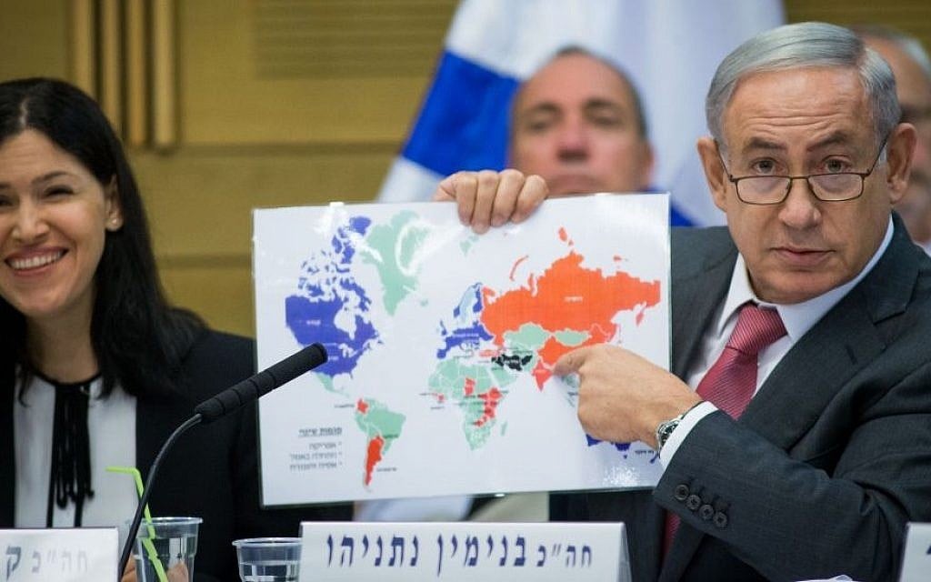
The red and blue colors dominated the map. Netanyahu, widely known for his pessimistic view of the international community and the reliability of political alliances, wanted to present a completely different image of Israel under his rule. The map’s core message was that Israel’s international relations were flourishing and expanding, and that the world had become more accepting of it and more willing to build partnerships with it.
This message was clear in the coloring of countries the size of China, India, Russia, Argentina, and Ethiopia in red, as states that had recently improved relations with Israel. By contrast, countries such as Lebanon, Yemen, Saudi Arabia, and Turkey did not appear in the black camp Netanyahu reserved for “enemies.”
The final takeaway the 2016 map sought to convey was simple and highly optimistic: Israel has dozens of old friends, dozens of new friends, and a vast number of potential future friends, against only a very limited number of adversaries.
But this contrast between the world of maps and the world of political realities which Netanyahu often ignores became even clearer in 2025, when a delegation representing 77 countries walked out of the UN hall amid jeers during his speech in September of that year. None of Netanyahu’s maps, whether before or after Oct. 7, showed that such a large number of countries could turn into a political or diplomatic adversary for Israel.
Some of those countries even continued to appear on his maps as part of the “blessing” surrounding Israel, or within the circle of current or potential friends, such as Egypt, Saudi Arabia, Sudan, Oman, Jordan, Turkey, Spain, and Ireland.
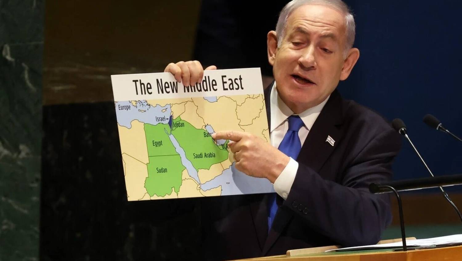
This color-coded division of the world, and the cartographic discourse accompanying it, began attracting wider attention with the September 2023 map Netanyahu displayed before the United Nations, just one month before Oct. 7, when he presented his vision of a prosperous “new Middle East” led by the Abraham Accords and in which the “walls of enmity” were collapsing.
At the time, that map represented the height of Israeli enthusiasm for the normalization track, especially the budding relationship with the UAE. Israel appeared on it as having fully absorbed the Gaza Strip, the West Bank, and East Jerusalem, while behind it stretched a broad green expanse including Jordan, the Sinai Peninsula, and the Gulf states, including Saudi Arabia.
The map’s visual design sought to portray Israel as a new economic and geographic center of the region. A huge red arrow pointed to “secure” trade corridors by land, sea, and air, in addition to a digital cable extending from India to the European Union what Netanyahu described at the time as a “bridge between continents.”
This is Netanyahu’s favorite theme: a secure Middle East serving Israeli interests, which are always presented as an extension of Western interests as well. Through this cartographic conception, Netanyahu reproduces the idea on which the mobilization of Western support for the Zionist project was built from the outset by promising to secure trade and transportation routes between Asia and Europe, and to connect India and China to the West through a stable space led by Israel.
This was, in essence, Theodor Herzl’s own promise during his travels and attempts to persuade European powers to support the Zionist project, as Mohamed Hassanein Heikal recounts in his book “Secret Negotiations Between the Arabs and Israel: Myth, Empire, and the Jewish State.”
In practical terms, this promise gave Israel a blank check that tied Western interests to the Zionist project for more than a century. That relationship was not limited to control over energy or resources in the Middle East, but also manifested in the role Israel played in serving colonial and post-colonial interests — something that appeared clearly and early during the 1956 tripartite aggression against Egypt and the Suez crisis.
In the year following the outbreak of the genocidal war on Gaza, Netanyahu returned to the United Nations with a new cartographic presentation titled “The Blessing and the Curse.” On that map, the countries representing the “curse” in the Middle East appeared in black: Lebanon, Iran, Iraq, Syria, and Yemen. It was notable that Yemen and Lebanon replaced North Korea and Afghanistan, which had appeared on the 2016 map a shift reflecting Israeli war priorities at the time, as Netanyahu was engaged in an open confrontation with Hezbollah and Ansar Allah. Just days after that presentation, Hezbollah Secretary-General Hassan Nasrallah was assassinated.
The countries representing the “blessing” on the map included Saudi Arabia, Egypt, Sudan, and the Gulf states, within a conception linking regional stability to normalization and the new alliances led by Israel.
In his latest cartographic presentation, Netanyahu emerged in mid-April 2026 with a new map of the Middle East reflecting the latest version of Israel’s shifting vision for the region. On it, Syria, Yemen, Iran, and Iraq appeared in red as countries falling within the camp led by Iran — a camp that Israel, in Netanyahu’s conception, had begun moving from a policy of containment to a policy of directly attacking.
This map differed from the “blessing and curse” map in that Lebanon was no longer included. After the assassination of Hassan Nasrallah, it seemed as though the reason Lebanon had previously been classified under the “curse” had receded or changed in Israeli calculations. But the clearer paradox was Syria’s continued classification within the hostile camp despite the fall of Bashar Assad’s regime at the end of 2024 a regime that had represented one of the main extensions of the Iranian axis.
Yet Netanyahu’s view of Syria did not change, and it remained present on his maps in red at times and black at others.
Perhaps this insistence carried a political message extending beyond Iran itself, as Syria, in Netanyahu’s conception, can be read as a potential arena for the next clash with Turkey after the confrontation with Iran is over, should circumstances allow.
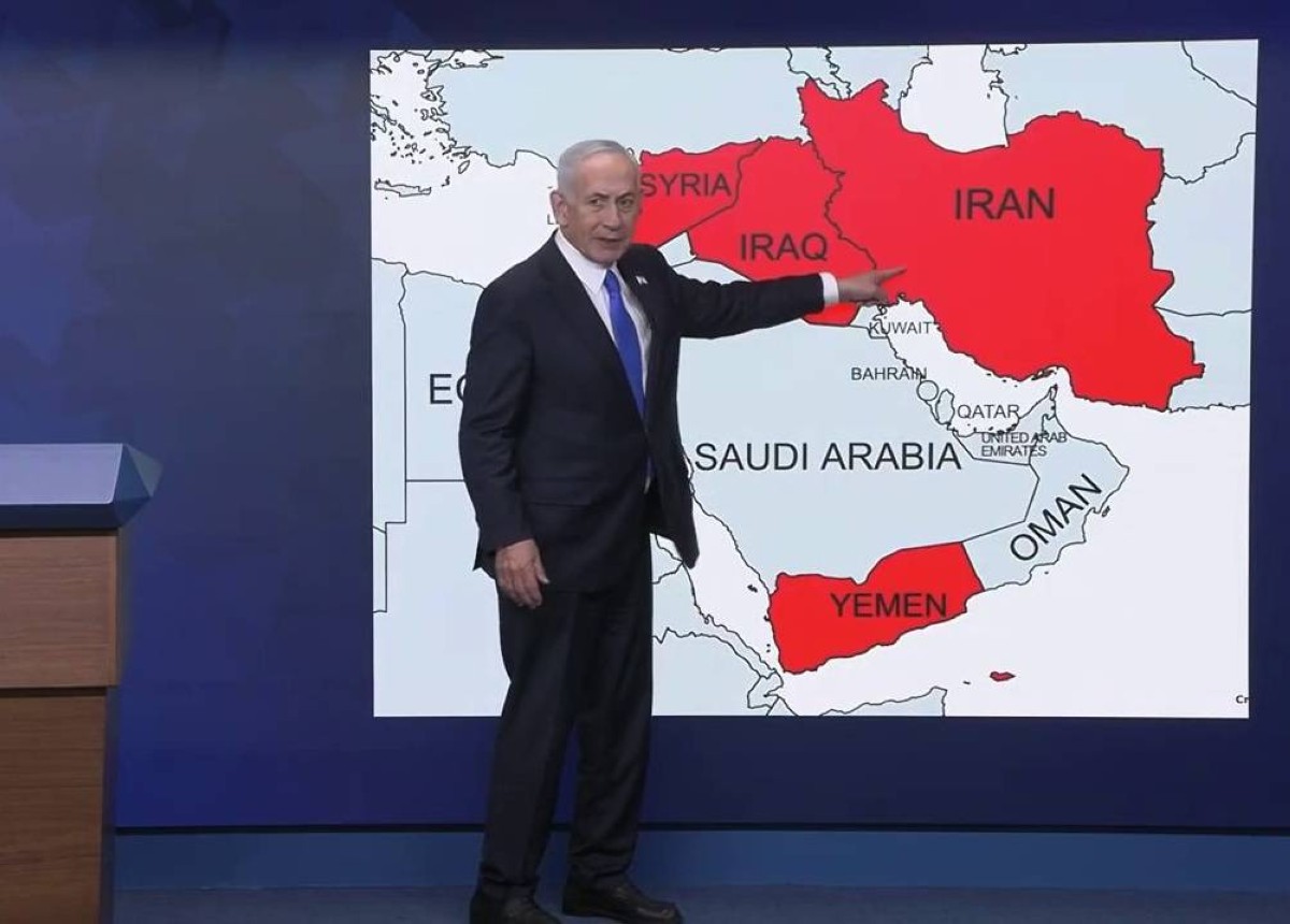
What the comparison between Netanyahu’s 2023 map of the “new Middle East” and his latest map in 2026 reveals is that the earlier focus was on regional integration, normalization, trade networks, and economic corridors led by Israel. In the 2026 map, however, that discourse receded in favor of a more security- and military-centered conception in which Iran was presented as the central obstacle to the emergence of a “stable” and secure Middle East.
Through this visual simplification of reality into maps, colors, and opposing axes, Netanyahu is trying to re-market Iran, once again, as the greatest threat facing both the West and the region. This is the same idea expressed last year by Israeli adviser Merz when he said that “Israel is doing the dirty work on behalf of the West through its attack on Iran.”
But the geopolitical realities that followed appeared more complex than Israeli maps suggested. When the war that directly threatened European interests broke out a year later, Israel found no real backing except from the United States, while both parties faced a broad wave of criticism not only from China and Russia, but also from many Western capitals that, according to the Israeli vision, were supposed to benefit from the “new Middle East” project.
At that moment, European enthusiasm for major Israeli projects in the region seemed much weaker than before. Even the United States itself no longer appeared to be a guaranteed partner in the long term, especially in the post-Donald Trump phase and with the rise of currents more skeptical of the relationship with Israel within the American right itself, long considered the most solid political incubator of the Israeli project in Washington.
Colors and words … the rhetoric of Netanyahu’s cartographic discourse
The matter does not end with Netanyahu simply presenting a map of facts or a future Middle East according to his perspective. If that were all, his cartographic discourse would not have drawn such great attention. Looking at the semiotics of Netanyahu’s cartographic discourse, we find that it carries considerable influence over local and global audiences. In his famous 2023 map, Netanyahu did not present the map of the new Middle East before first displaying a blank map of tiny Israel in 1948, surrounded by a hostile environment bent on its destruction.
Although the David-versus-Goliath narrative had weakened since the 1967 war the image Israel had always promoted of itself Netanyahu was keen in that cartographic discourse to revive it once more, to show the world the miracle of David, who endured in a sea of giants and even turned those giants themselves into a belt of friends and allies.
In that map as well, Palestinian existence was erased entirely, provoking much controversy. In his journalistic justifications that followed the incident, Netanyahu underscored the force of the Likud idea in its new form with the rise of Itamar Ben-Gvir and Bezalel Smotrich. When asked why he had deleted the entire West Bank from his map, he replied mockingly: “I didn’t include the Dead Sea either, I didn’t include the Jordan River, and I didn’t include the Sea of Galilee.”
Netanyahu does not appear to see Palestinians or internationally recognized Palestinian sites as having any real topographic or geographic existence. It is clear that he deliberately removed the West Bank, just as he has removed it from his linguistic lexicon, constantly referring to “Judea and Samaria,” not the West Bank.