










هذا التقرير متاح أيضًا بـ العربية
Egypt’s latest petroleum agreements are spread across three areas for gas and crude oil exploration in the Mediterranean, the Nile Delta and North Sinai, along with a fourth area for developing an existing oil field in the Gulf of Suez.
The package combines an offshore block with a long record of wells and seismic surveys, an onshore tract within the mature Nile Delta basin, a less explored frontier in North Sinai, and a field the state is seeking to extend the life of and increase recoverable output from its reservoirs.
The three exploration areas began as part of a bid round launched by the Egyptian Natural Gas Holding Company, EGAS, the state-owned company responsible for managing natural gas activities and agreements, during 2024. On June 25, 2025, it announced the award of East Alexandria, North Tanta and Al-Fayrouz to the winning companies.
On June 4, 2026, the Egyptian Cabinet approved the four draft agreements, before the House of Representatives granted its final approval in a plenary session on July 22, 2026. The government announced a total minimum investment of $52.97 million, along with a commitment to drill six wells.
A report by the House Energy and Environment Committee shows that this amount is allocated arithmetically across the three exploration agreements: $42.2 million for East Alexandria, $4.4 million for North Tanta and $6.37 million for Al-Fayrouz. Asran, meanwhile, is governed by a development agreement for an existing field and a separate investment plan.
1- East Alexandria offshore
The East Alexandria offshore area covers about 1,997 square kilometers off the northern coast, within the offshore extension of the Nile Delta.
On the concessions map issued by the Egypt Upstream Gateway, the Egyptian Ministry of Petroleum and Mineral Resources’ official digital platform, it appears as a standalone area adjacent to the West El Burullus offshore concession and within the same corridor that includes the West Delta Deep Marine projects.
In this area, EGAS has contracted with Cheiron Egypt Delta Ltd., part of the Cheiron Group, which operates in exploration and production. The exploration period runs for eight years, divided into three phases of three years, three years and two years, with minimum investments of $14.8 million in the first phase, $14.4 million in the second and $13 million in the third.
The work program includes drilling three exploratory wells and reprocessing seismic data — reanalyzing the images that reveal the shape of layers and rocks beneath the seabed — in addition to a nonrefundable signature bonus of $1 million payable to EGAS, according to the Egyptian business newspaper Al-Mal during discussion of the draft agreement in the Energy and Environment Committee in July 2026.
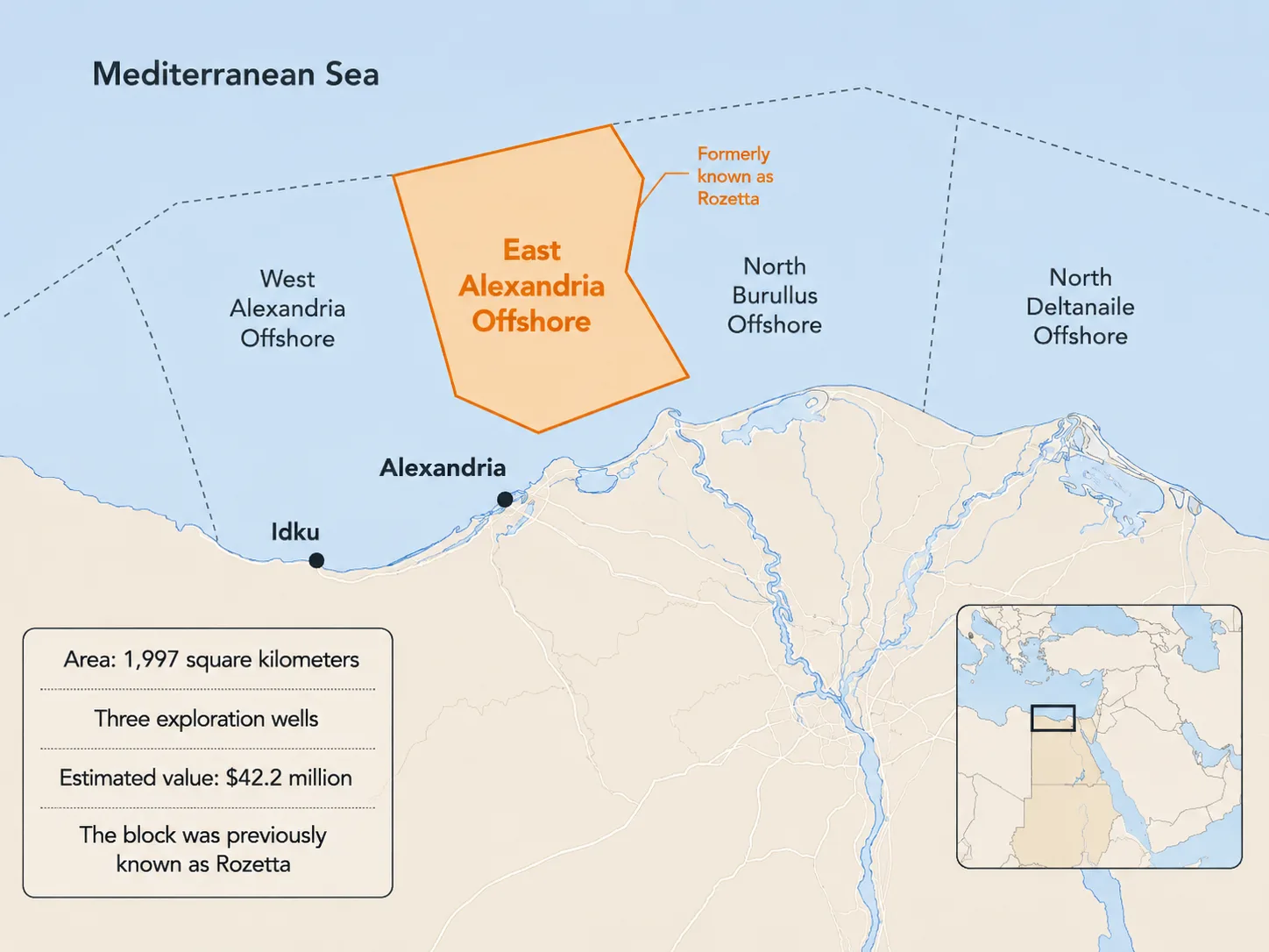
The concession bears a new name for a block previously known as Rashid or Rosetta. Offering materials and specialized bulletins indicate that 22 wells were drilled within its boundaries during earlier work phases, while 3D seismic surveys — detailed images of subsurface layers and faults — cover about 95% of its area.
This means Cheiron is entering an area with a broad data base, where its task centers on reinterpreting seismic images and identifying potential gas accumulations that earlier wells did not reach.
The block lies within the offshore Nile Delta basin, where thick layers of sand and clay accumulated over more than 30 million years. As the delta extended into the sea, sandy layers formed that could store gas, while faults and rock folds helped trap it inside.
Modern seismic processing techniques make it possible to improve the image of layers and faults and reassess targets that appeared only with limited quality in older data. The bet in East Alexandria, therefore, is tied to finding new opportunities within a block that has already been extensively tested, benefiting from advances in imaging and analysis tools and from the accumulated knowledge of the area’s geology.
The open documents do not include a detailed map specifying water depths within the new concession’s boundaries, but the progress of previous and neighboring projects offers a picture of the marine environment’s diversity. Some Rosetta wells are in waters about 160 meters deep, while other projects in the area extended across depths ranging from 70 to 570 meters, and depths in parts of the West Delta Deep Marine area exceeded 1,000 meters.
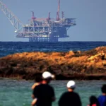
The area is close to a network of offshore fields, pipelines, gas reception and processing facilities on the coast, as well as the Idku Energy Center and two LNG plants.
The location, size and characteristics of any potential discoveries will determine the tie-in route and the facility that could receive production, while the distances between the concession boundaries and existing infrastructure remain outside the published documents.
East Alexandria accounts for $42.2 million of the $52.97 million allocated to the three exploration agreements, reflecting the cost of offshore wells and related services. The area combines the risk of offshore drilling with the advantage of available data, infrastructure and the operating experience accumulated in the West Delta Deep Marine area.
2- North Tanta onshore
The North Tanta area extends over about 1,111 square kilometers within the Nile Delta. There, EGAS has contracted with IPR South Disouq Ltd., part of the IPR Group, which operates in Egypt’s oil and gas sector. The agreement grants the company an initial exploration period of three years, with the right to move to a second period of two years.
The minimum investment is $4.4 million, divided between $2.4 million in the first period and $2 million in the second, in addition to a $1 million signature bonus. The program also requires the company to reprocess seismic data and drill two exploratory wells.
And it places Map North Tanta on Egypt’s Exploration and Production Gateway falls within the group of onshore concession areas in the Nile Delta, in the same region where South Disouq and Ibn Younes appear. The contracting entity also bears the name “South Disouq,” while North Tanta retains a separate agreement and its own boundaries.
The region contains facilities for processing gas produced from South Disouq, along with pipelines linking it to the national grid, reflecting the density of infrastructure in this part of the delta.
The available maps did not include coordinates that would make it possible to measure the exact distance between North Tanta and the South Disouq processing plant or identify the facilities that may receive the area’s production in the future.
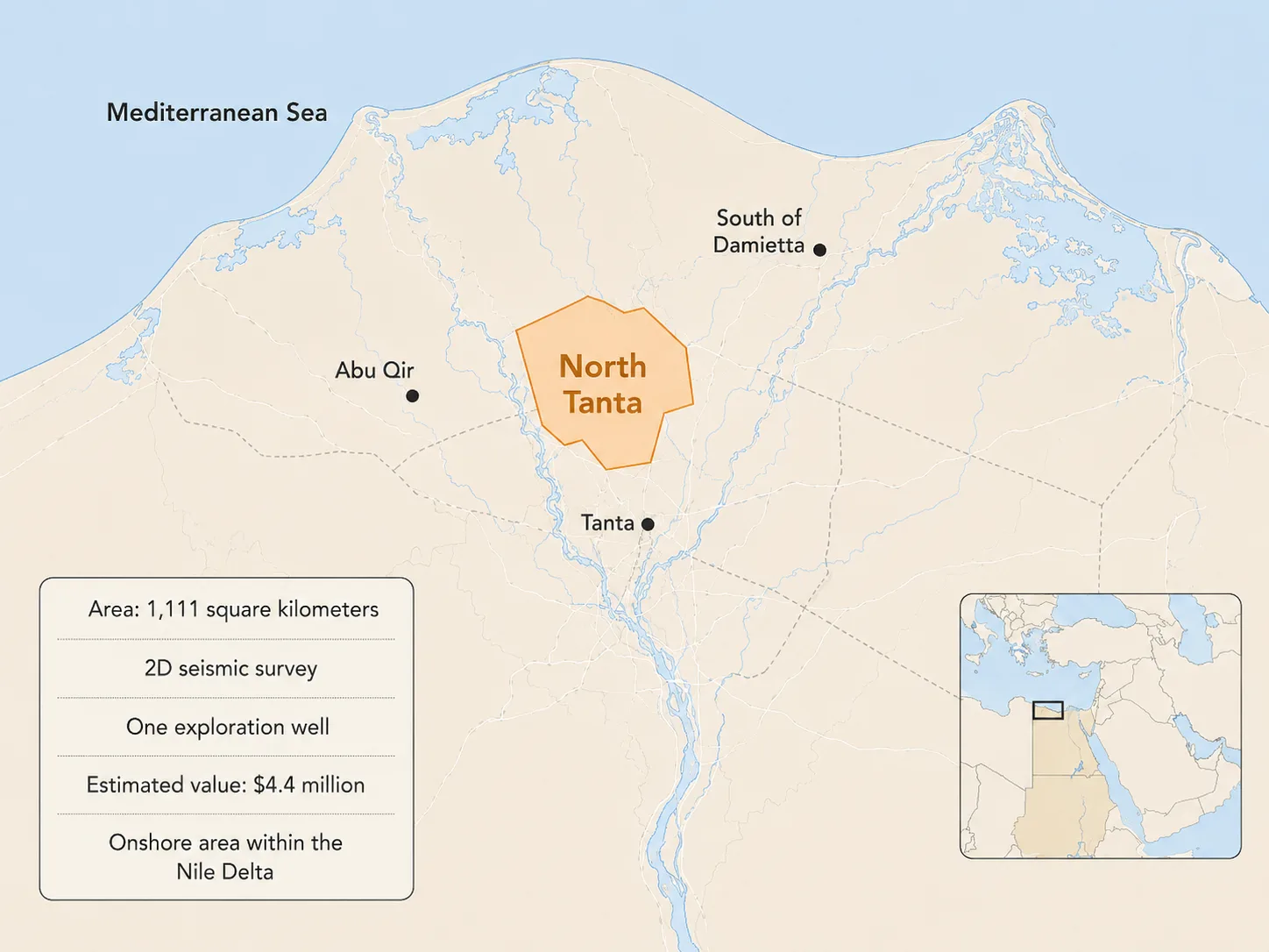
North Tanta belongs to a basin that has seen decades of exploration and production, with extensive seismic data and well records accumulated over time. Updating the processing of these data can improve the imaging of sandstone layers, faults, and traps, and uncover small- or medium-sized gas accumulations that remained outside previous drilling plans.
The proximity of gas pipelines and processing facilities lowers the cost of developing discoveries compared with areas far from the grid, while onshore wells require less spending than offshore wells. This is reflected in the allocation of $4.4 million to drill two wells and reprocess data in North Tanta, compared with $42.2 million for three offshore wells in East Alexandria.
The bet in this area is on reaching discoveries that can be tied in within a region that already has production and transport facilities, even when their volumes are smaller than those of major offshore fields.
The actual distance to gathering lines (which carry gas from wells to processing plants) affects the economic viability of any discovery, and those distances require detailed concession maps.
3- Al Fayrouz Onshore
The Al Fayrouz area is located on land in North Sinai and appears on Egypt’s Exploration and Production Gateway map as an independent concession. A report by the Energy and Environment Committee estimated its area at about 644 square kilometers, while the boundary map and coordinate table remained unavailable.
And EGAS has contracted in the area with Brenco North Sinai Petroleum, a subsidiary of the French Brenco Group active in exploration and production. The company is committed to investing at least $6.37 million, carrying out a 3D seismic survey and reprocessing previous data, then drilling one exploratory well, along with a signature bonus of $500,000.
The agreement followed a direct offer submitted by Brenco and subjected to technical and economic evaluation within EGAS committees, according to the explanatory memorandum reviewed by the Energy and Environment Committee.
The company has prior experience in North Sinai and producing assets in its offshore zone, giving it knowledge of the geological environment, operating conditions, and supply chains in the area.
The program begins with the 3D seismic survey before selecting the well location. This stage is aimed at accurately mapping the shape of the layers and faults and choosing the site most likely to contain gas.
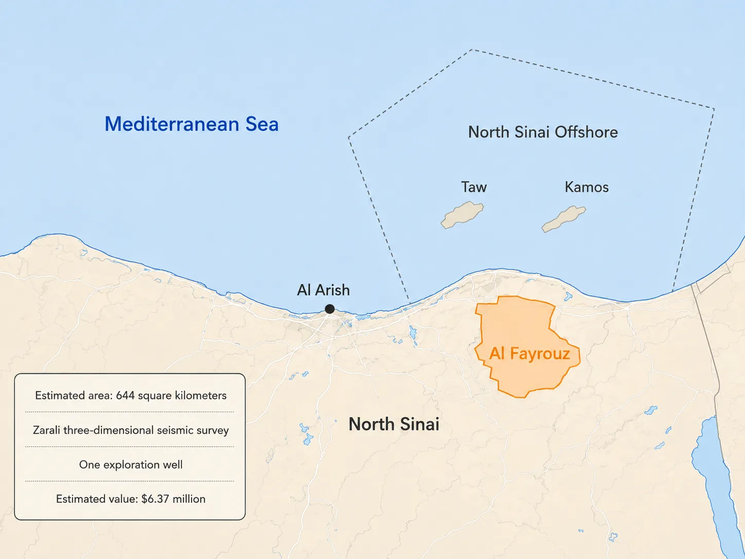
Al Fayrouz lies at the eastern edge of the Nile Delta and North Sinai system, within a region whose offshore area has revealed the presence of an active gas system.
Published technical studies on offshore North Sinai indicate the presence of gas reservoirs within sandstone layers deposited millions of years ago, and geological structures formed by faults in fields such as Tao and Kamos.
The results of the offshore Tao and Kamos fields help in understanding the potential for gas in the wider area, while the Al Fayrouz onshore block is undergoing an independent test through the new seismic survey and the planned well to determine the nature of the layers and the locations of gas accumulations within its boundaries.
The maps show regional proximity between Al Fayrouz and the offshore North Sinai area, without identifying a pipeline or processing plant linked to the new concession. As a result, the picture of the operating infrastructure depends on the location of any potential discovery and its distance from existing facilities in North Sinai.
Al Fayrouz carries a higher degree of geological uncertainty than North Tanta, which explains the allocation of a 3D survey before the first well. The area represents an attempt to open a new onshore front, drawing on the operator’s experience in the region and the gas indications that have appeared in the adjacent offshore zone.
4- Asran in North Amer
The fourth agreement concerns the development of the Asran field in North Amer. Under it, the state is contracting with the state-owned General Petroleum Co., which is active in exploration and production and operates onshore and offshore fields. The agreement covers the continuation of exploration, development, and exploitation within an existing field after the current award period expires.
A report by the Energy and Environment Committee estimated the development area at about 909 square kilometers, while the agreement grants the General Petroleum Co. a 20-year exploitation period, renewable within an overall ceiling of up to 30 years.
Some summaries of the draft agreement place the start of the award in December 2030, while other sources tie its entry into force to the expiration of the current agreement on Nov. 30, 2032.
The procedures for re-awarding the area began with a request submitted by the General Petroleum Co. on Oct. 31, 2024, to ensure the continuation of development and production activities.
In February 2026, the minister of petroleum and mineral resources approved the company’s investment plan, which included accelerating the development of the Asran field with investments of $350 million over the first five years. This amount represents a field development plan separate from the investments in the three exploration agreements.
The field’s official name links it to the North Amer area in the Eastern Desert, while technical data for the North and West Amer blocks place the area within the coastal belt of the Gulf of Suez near Ras Gharib.
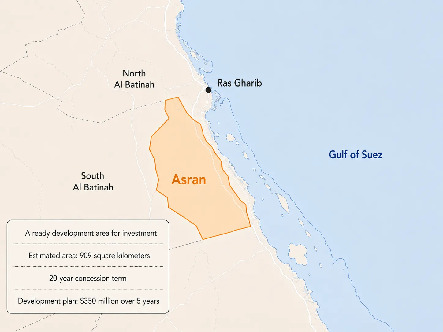
Data from the adjacent West Amer sector show that it includes both onshore sections and shallow offshore areas, while the boundaries of the Asran area itself require the map attached to the law to determine its precise extent.
The General Petroleum Co. operates existing wells, platforms and production facilities in the North and West Amer area, allowing the Asran plan to benefit from an operating network built over decades. Investments are focused on drilling additional wells, returning some idle wells to production, maintaining facilities and reassessing reservoirs that have reached an advanced stage of their life cycle.
The field belongs to the province of the Gulf of Suez, one of Egypt’s oldest and most important oil-producing regions. The gulf was formed by faults that split the Earth’s crust and created basins where organic matter, sandstone layers and rocks accumulated, helping generate oil, store it and prevent its seepage.
Plans to develop mature fields are aimed at identifying the remaining recoverable quantities, increasing the share of oil that can be extracted from the field, and drilling targets close to existing wells and facilities. That requires updating models that track the movement of oil, water and pressure within the reservoir, and linking the results of older wells with modern seismic and production data.
The Asran plan is in line with the Petroleum Ministry’s push to expand the use of digital analysis and artificial intelligence in mature fields. These tools help review well records, production rates and pressure, identify suitable locations for drilling new wells, and determine which wells need repair or reactivation.
